You are here: Home > Network List > IU - Global Seismograph Network (GSN - IRIS/USGS) Stations List
> Station JOHN Johnston Island, USA > Earthquake Result Viewer
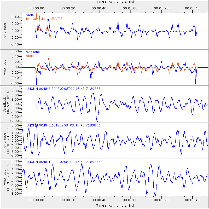
JOHN Johnston Island, USA - Earthquake Result Viewer
*The percent match for this event was below the threshold and hence no stack was calculated.
| Earthquake location: |
Santa Cruz Islands Region |
| Earthquake latitude/longitude: |
-10.9/164.7 |
| Earthquake time(UTC): |
2013/02/08 (039) 09:09:00 GMT |
| Earthquake Depth: |
6.0 km |
| Earthquake Magnitude: |
5.5 MW, 5.5 MW |
| Earthquake Catalog/Contributor: |
NEIC PDE/NEIC PDE-W |
|
| Network: |
IU Global Seismograph Network (GSN - IRIS/USGS) |
| Station: |
JOHN Johnston Island, USA |
| Lat/Lon: |
16.73 N/169.53 W |
| Elevation: |
2.0 m |
|
| Distance: |
37.4 deg |
| Az: |
43.168 deg |
| Baz: |
224.527 deg |
| Ray Param: |
$rayparam |
*The percent match for this event was below the threshold and hence was not used in the summary stack. |
|
| Radial Match: |
42.53853 % |
| Radial Bump: |
388 |
| Transverse Match: |
50.043156 % |
| Transverse Bump: |
400 |
| SOD ConfigId: |
558545 |
| Insert Time: |
2013-09-18 06:24:55.631 +0000 |
| GWidth: |
2.5 |
| Max Bumps: |
400 |
| Tol: |
0.001 |
|
Signal To Noise
| Channel | StoN | STA | LTA |
| IU:JOHN:00:BHZ:20130208T09:15:43.718987Z | 1.9214902 | 5.1789116E-6 | 2.6952578E-6 |
| IU:JOHN:00:BH1:20130208T09:15:43.718987Z | 0.8558856 | 2.0720677E-6 | 2.420963E-6 |
| IU:JOHN:00:BH2:20130208T09:15:43.718987Z | 1.5312697 | 4.130172E-6 | 2.6972205E-6 |
| Arrivals |
| Ps | |
| PpPs | |
| PsPs/PpSs | |


