You are here: Home > Network List > US - United States National Seismic Network Stations List
> Station ELK Elko, Nevada, USA > Earthquake Result Viewer
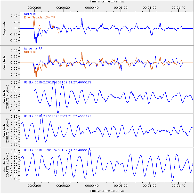
ELK Elko, Nevada, USA - Earthquake Result Viewer
*The percent match for this event was below the threshold and hence no stack was calculated.
| Earthquake location: |
Santa Cruz Islands Region |
| Earthquake latitude/longitude: |
-10.9/164.7 |
| Earthquake time(UTC): |
2013/02/08 (039) 09:09:00 GMT |
| Earthquake Depth: |
6.0 km |
| Earthquake Magnitude: |
5.5 MW, 5.5 MW |
| Earthquake Catalog/Contributor: |
NEIC PDE/NEIC PDE-W |
|
| Network: |
US United States National Seismic Network |
| Station: |
ELK Elko, Nevada, USA |
| Lat/Lon: |
40.74 N/115.24 W |
| Elevation: |
2210 m |
|
| Distance: |
89.6 deg |
| Az: |
48.443 deg |
| Baz: |
255.308 deg |
| Ray Param: |
$rayparam |
*The percent match for this event was below the threshold and hence was not used in the summary stack. |
|
| Radial Match: |
70.744156 % |
| Radial Bump: |
400 |
| Transverse Match: |
84.28648 % |
| Transverse Bump: |
400 |
| SOD ConfigId: |
558545 |
| Insert Time: |
2013-09-18 06:25:44.874 +0000 |
| GWidth: |
2.5 |
| Max Bumps: |
400 |
| Tol: |
0.001 |
|
Signal To Noise
| Channel | StoN | STA | LTA |
| US:ELK:00:BHZ:20130208T09:21:27.400017Z | 1.3979055 | 4.4779406E-7 | 3.2033216E-7 |
| US:ELK:00:BH1:20130208T09:21:27.400017Z | 1.721914 | 2.3076572E-7 | 1.3401699E-7 |
| US:ELK:00:BH2:20130208T09:21:27.400017Z | 0.6169408 | 2.1020952E-7 | 3.4072883E-7 |
| Arrivals |
| Ps | |
| PpPs | |
| PsPs/PpSs | |


