You are here: Home > Network List > II - Global Seismograph Network (GSN - IRIS/IDA) Stations List
> Station KAPI Kappang, Sulawesi, Indonesia > Earthquake Result Viewer
KAPI Kappang, Sulawesi, Indonesia - Earthquake Result Viewer

| Earthquake location: |
Santa Cruz Islands |
| Earthquake latitude/longitude: |
-10.8/166.0 |
| Earthquake time(UTC): |
2013/02/08 (039) 11:12:11 GMT |
| Earthquake Depth: |
12 km |
| Earthquake Magnitude: |
6.3 MB, 6.9 MS, 6.8 MW, 6.8 MW |
| Earthquake Catalog/Contributor: |
WHDF/NEIC |
|
| Network: |
II Global Seismograph Network (GSN - IRIS/IDA) |
| Station: |
KAPI Kappang, Sulawesi, Indonesia |
| Lat/Lon: |
5.01 S/119.75 E |
| Elevation: |
300 m |
|
| Distance: |
46.1 deg |
| Az: |
273.46 deg |
| Baz: |
100.159 deg |
| Ray Param: |
0.07084839 |
| Estimated Moho Depth: |
37.75 km |
| Estimated Crust Vp/Vs: |
1.82 |
| Assumed Crust Vp: |
6.343 km/s |
| Estimated Crust Vs: |
3.495 km/s |
| Estimated Crust Poisson's Ratio: |
0.28 |
|
| Radial Match: |
95.085106 % |
| Radial Bump: |
345 |
| Transverse Match: |
86.988914 % |
| Transverse Bump: |
400 |
| SOD ConfigId: |
558545 |
| Insert Time: |
2013-09-18 06:26:37.885 +0000 |
| GWidth: |
2.5 |
| Max Bumps: |
400 |
| Tol: |
0.001 |
|
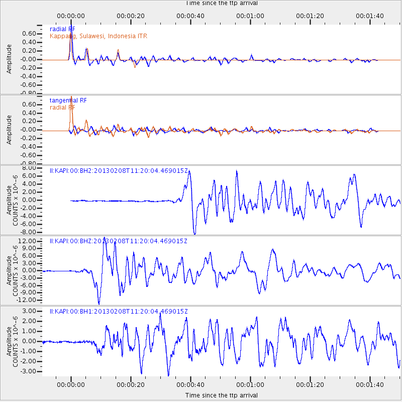
Signal To Noise
| Channel | StoN | STA | LTA |
| II:KAPI:00:BHZ:20130208T11:20:04.469015Z | 3.8786426 | 3.157133E-7 | 8.1397886E-8 |
| II:KAPI:00:BH1:20130208T11:20:04.469015Z | 0.75333077 | 3.961236E-8 | 5.2582955E-8 |
| II:KAPI:00:BH2:20130208T11:20:04.469015Z | 1.9611338 | 1.3276946E-7 | 6.770035E-8 |
| Arrivals |
| Ps | 5.1 SECOND |
| PpPs | 16 SECOND |
| PsPs/PpSs | 21 SECOND |


