You are here: Home > Network List > II - Global Seismograph Network (GSN - IRIS/IDA) Stations List
> Station KAPI Kappang, Sulawesi, Indonesia > Earthquake Result Viewer
KAPI Kappang, Sulawesi, Indonesia - Earthquake Result Viewer

| Earthquake location: |
Santa Cruz Islands |
| Earthquake latitude/longitude: |
-10.9/166.0 |
| Earthquake time(UTC): |
2013/02/08 (039) 15:26:38 GMT |
| Earthquake Depth: |
21 km |
| Earthquake Magnitude: |
6.4 MB, 6.9 MS, 7.1 MW, 7.1 MW |
| Earthquake Catalog/Contributor: |
WHDF/NEIC |
|
| Network: |
II Global Seismograph Network (GSN - IRIS/IDA) |
| Station: |
KAPI Kappang, Sulawesi, Indonesia |
| Lat/Lon: |
5.01 S/119.75 E |
| Elevation: |
300 m |
|
| Distance: |
46.2 deg |
| Az: |
273.533 deg |
| Baz: |
100.279 deg |
| Ray Param: |
0.070792146 |
| Estimated Moho Depth: |
39.0 km |
| Estimated Crust Vp/Vs: |
1.76 |
| Assumed Crust Vp: |
6.343 km/s |
| Estimated Crust Vs: |
3.609 km/s |
| Estimated Crust Poisson's Ratio: |
0.26 |
|
| Radial Match: |
96.16616 % |
| Radial Bump: |
302 |
| Transverse Match: |
88.072174 % |
| Transverse Bump: |
400 |
| SOD ConfigId: |
558545 |
| Insert Time: |
2013-09-18 06:30:50.676 +0000 |
| GWidth: |
2.5 |
| Max Bumps: |
400 |
| Tol: |
0.001 |
|
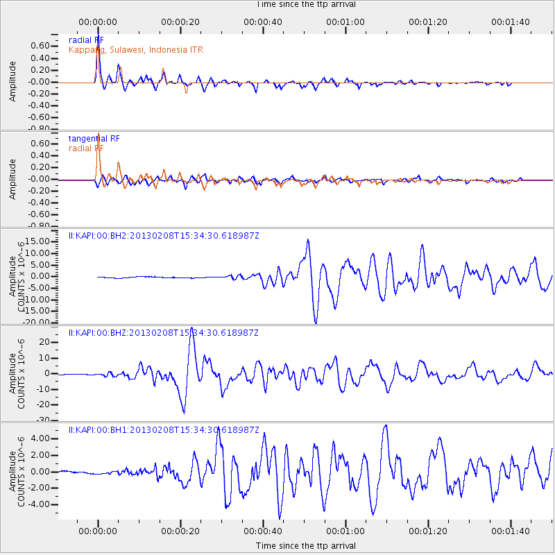
Signal To Noise
| Channel | StoN | STA | LTA |
| II:KAPI:00:BHZ:20130208T15:34:30.618987Z | 3.5079305 | 9.509985E-7 | 2.710996E-7 |
| II:KAPI:00:BH1:20130208T15:34:30.618987Z | 0.9783573 | 1.4355025E-7 | 1.467258E-7 |
| II:KAPI:00:BH2:20130208T15:34:30.618987Z | 3.0560884 | 6.958094E-7 | 2.2767972E-7 |
| Arrivals |
| Ps | 5.0 SECOND |
| PpPs | 16 SECOND |
| PsPs/PpSs | 21 SECOND |


