You are here: Home > Network List > US - United States National Seismic Network Stations List
> Station AMTX Amarillo, Texas, USA > Earthquake Result Viewer
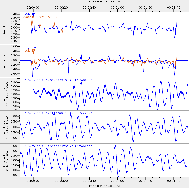
AMTX Amarillo, Texas, USA - Earthquake Result Viewer
*The percent match for this event was below the threshold and hence no stack was calculated.
| Earthquake location: |
Santa Cruz Islands |
| Earthquake latitude/longitude: |
-10.9/166.0 |
| Earthquake time(UTC): |
2013/02/09 (040) 05:32:07 GMT |
| Earthquake Depth: |
9.0 km |
| Earthquake Magnitude: |
5.5 MB, 5.2 MS, 5.5 MW, 5.6 MW |
| Earthquake Catalog/Contributor: |
WHDF/NEIC |
|
| Network: |
US United States National Seismic Network |
| Station: |
AMTX Amarillo, Texas, USA |
| Lat/Lon: |
34.53 N/101.41 W |
| Elevation: |
1010 m |
|
| Distance: |
98.2 deg |
| Az: |
56.439 deg |
| Baz: |
262.48 deg |
| Ray Param: |
$rayparam |
*The percent match for this event was below the threshold and hence was not used in the summary stack. |
|
| Radial Match: |
54.51469 % |
| Radial Bump: |
400 |
| Transverse Match: |
55.29137 % |
| Transverse Bump: |
400 |
| SOD ConfigId: |
558545 |
| Insert Time: |
2013-09-18 06:40:03.701 +0000 |
| GWidth: |
2.5 |
| Max Bumps: |
400 |
| Tol: |
0.001 |
|
Signal To Noise
| Channel | StoN | STA | LTA |
| US:AMTX:00:BHZ:20130209T05:45:12.749985Z | 0.63562775 | 2.7210004E-7 | 4.280808E-7 |
| US:AMTX:00:BH1:20130209T05:45:12.749985Z | 1.0338957 | 9.470748E-7 | 9.1602544E-7 |
| US:AMTX:00:BH2:20130209T05:45:12.749985Z | 3.5811455 | 7.21571E-7 | 2.0149166E-7 |
| Arrivals |
| Ps | |
| PpPs | |
| PsPs/PpSs | |


