You are here: Home > Network List > US - United States National Seismic Network Stations List
> Station DGMT Dagmar, Montana, USA > Earthquake Result Viewer
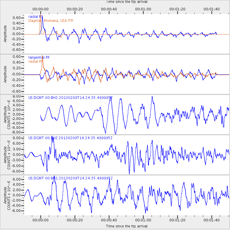
DGMT Dagmar, Montana, USA - Earthquake Result Viewer
*The percent match for this event was below the threshold and hence no stack was calculated.
| Earthquake location: |
Colombia |
| Earthquake latitude/longitude: |
1.1/-77.4 |
| Earthquake time(UTC): |
2013/02/09 (040) 14:16:07 GMT |
| Earthquake Depth: |
145 km |
| Earthquake Magnitude: |
6.7 MB, 6.9 MW, 6.9 MW |
| Earthquake Catalog/Contributor: |
WHDF/NEIC |
|
| Network: |
US United States National Seismic Network |
| Station: |
DGMT Dagmar, Montana, USA |
| Lat/Lon: |
48.47 N/104.20 W |
| Elevation: |
0.0 m |
|
| Distance: |
52.5 deg |
| Az: |
337.779 deg |
| Baz: |
145.379 deg |
| Ray Param: |
$rayparam |
*The percent match for this event was below the threshold and hence was not used in the summary stack. |
|
| Radial Match: |
56.902485 % |
| Radial Bump: |
339 |
| Transverse Match: |
67.6823 % |
| Transverse Bump: |
400 |
| SOD ConfigId: |
558545 |
| Insert Time: |
2013-09-18 06:43:21.760 +0000 |
| GWidth: |
2.5 |
| Max Bumps: |
400 |
| Tol: |
0.001 |
|
Signal To Noise
| Channel | StoN | STA | LTA |
| US:DGMT:00:BHZ:20130209T14:24:35.499995Z | 4.8543153 | 3.364223E-6 | 6.930376E-7 |
| US:DGMT:00:BH1:20130209T14:24:35.499995Z | 1.6657828 | 1.7699613E-6 | 1.0625403E-6 |
| US:DGMT:00:BH2:20130209T14:24:35.499995Z | 0.8379251 | 1.9980596E-6 | 2.3845325E-6 |
| Arrivals |
| Ps | |
| PpPs | |
| PsPs/PpSs | |


