You are here: Home > Network List > US - United States National Seismic Network Stations List
> Station HAWA Hanford, Washington, USA > Earthquake Result Viewer
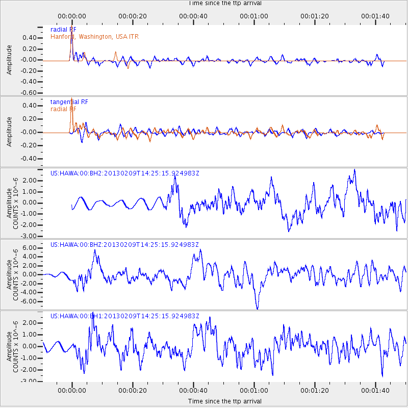
HAWA Hanford, Washington, USA - Earthquake Result Viewer
*The percent match for this event was below the threshold and hence no stack was calculated.
| Earthquake location: |
Colombia |
| Earthquake latitude/longitude: |
1.1/-77.4 |
| Earthquake time(UTC): |
2013/02/09 (040) 14:16:07 GMT |
| Earthquake Depth: |
145 km |
| Earthquake Magnitude: |
6.7 MB, 6.9 MW, 6.9 MW |
| Earthquake Catalog/Contributor: |
WHDF/NEIC |
|
| Network: |
US United States National Seismic Network |
| Station: |
HAWA Hanford, Washington, USA |
| Lat/Lon: |
46.39 N/119.53 W |
| Elevation: |
364 m |
|
| Distance: |
58.2 deg |
| Az: |
326.869 deg |
| Baz: |
127.861 deg |
| Ray Param: |
$rayparam |
*The percent match for this event was below the threshold and hence was not used in the summary stack. |
|
| Radial Match: |
71.99429 % |
| Radial Bump: |
400 |
| Transverse Match: |
57.04368 % |
| Transverse Bump: |
400 |
| SOD ConfigId: |
558545 |
| Insert Time: |
2013-09-18 06:43:53.962 +0000 |
| GWidth: |
2.5 |
| Max Bumps: |
400 |
| Tol: |
0.001 |
|
Signal To Noise
| Channel | StoN | STA | LTA |
| US:HAWA:00:BHZ:20130209T14:25:15.924983Z | 4.2377367 | 1.7258892E-6 | 4.0726673E-7 |
| US:HAWA:00:BH1:20130209T14:25:15.924983Z | 1.7602195 | 9.486593E-7 | 5.3894377E-7 |
| US:HAWA:00:BH2:20130209T14:25:15.924983Z | 3.3769035 | 1.052202E-6 | 3.1158783E-7 |
| Arrivals |
| Ps | |
| PpPs | |
| PsPs/PpSs | |


