You are here: Home > Network List > US - United States National Seismic Network Stations List
> Station MNTX Cornudas Mountains, Texas, USA > Earthquake Result Viewer
MNTX Cornudas Mountains, Texas, USA - Earthquake Result Viewer
| Earthquake location: |
Colombia |
| Earthquake latitude/longitude: |
1.1/-77.4 |
| Earthquake time(UTC): |
2013/02/09 (040) 14:16:07 GMT |
| Earthquake Depth: |
145 km |
| Earthquake Magnitude: |
6.7 MB, 6.9 MW, 6.9 MW |
| Earthquake Catalog/Contributor: |
WHDF/NEIC |
|
| Network: |
US United States National Seismic Network |
| Station: |
MNTX Cornudas Mountains, Texas, USA |
| Lat/Lon: |
31.70 N/105.38 W |
| Elevation: |
404 m |
|
| Distance: |
40.3 deg |
| Az: |
321.78 deg |
| Baz: |
133.475 deg |
| Ray Param: |
0.073964536 |
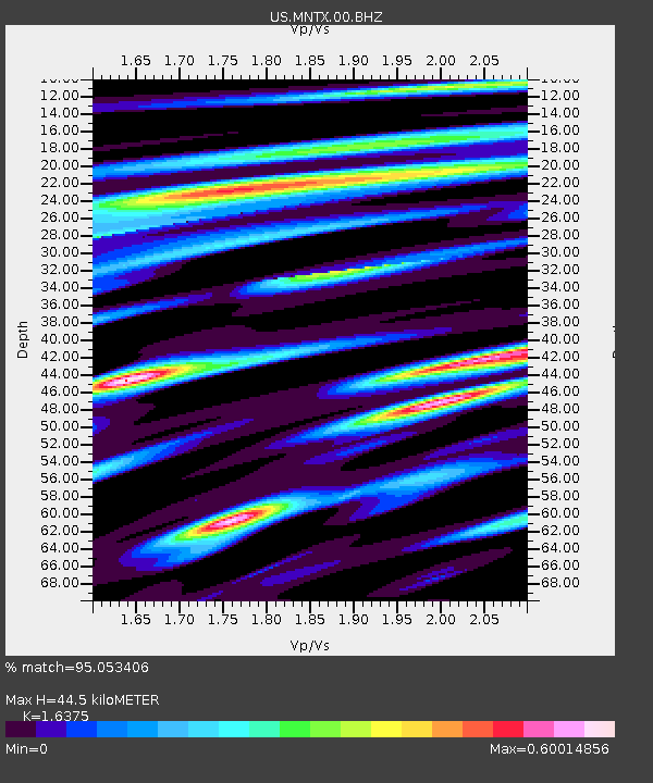
| Estimated Moho Depth: |
44.5 km |
| Estimated Crust Vp/Vs: |
1.64 |
| Assumed Crust Vp: |
6.361 km/s |
| Estimated Crust Vs: |
3.884 km/s |
| Estimated Crust Poisson's Ratio: |
0.20 |
|
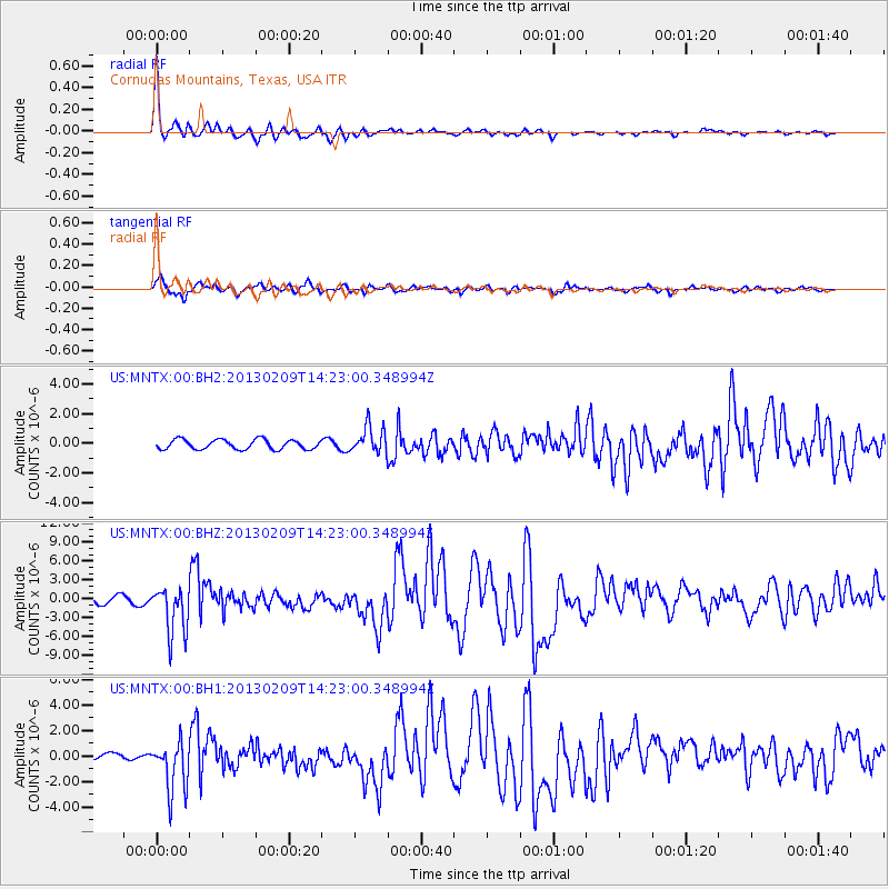
| Radial Match: |
95.053406 % |
| Radial Bump: |
323 |
| Transverse Match: |
79.85029 % |
| Transverse Bump: |
400 |
| SOD ConfigId: |
558545 |
| Insert Time: |
2013-09-18 06:44:40.667 +0000 |
| GWidth: |
2.5 |
| Max Bumps: |
400 |
| Tol: |
0.001 |
|
Signal To Noise
| Channel | StoN | STA | LTA |
| US:MNTX:00:BHZ:20130209T14:23:00.348994Z | 6.7673287 | 3.8008457E-6 | 5.616464E-7 |
| US:MNTX:00:BH1:20130209T14:23:00.348994Z | 8.13081 | 1.9957145E-6 | 2.4545088E-7 |
| US:MNTX:00:BH2:20130209T14:23:00.348994Z | 2.7907953 | 9.0141765E-7 | 3.2299667E-7 |
| Arrivals |
| Ps | 4.8 SECOND |
| PpPs | 17 SECOND |
| PsPs/PpSs | 22 SECOND |


