You are here: Home > Network List > US - United States National Seismic Network Stations List
> Station NATX Nacogdoches, Texas, USA > Earthquake Result Viewer
NATX Nacogdoches, Texas, USA - Earthquake Result Viewer

| Earthquake location: |
Colombia |
| Earthquake latitude/longitude: |
1.1/-77.4 |
| Earthquake time(UTC): |
2013/02/09 (040) 14:16:07 GMT |
| Earthquake Depth: |
145 km |
| Earthquake Magnitude: |
6.7 MB, 6.9 MW, 6.9 MW |
| Earthquake Catalog/Contributor: |
WHDF/NEIC |
|
| Network: |
US United States National Seismic Network |
| Station: |
NATX Nacogdoches, Texas, USA |
| Lat/Lon: |
31.76 N/94.66 W |
| Elevation: |
156 m |
|
| Distance: |
34.6 deg |
| Az: |
333.524 deg |
| Baz: |
148.449 deg |
| Ray Param: |
0.07719345 |
| Estimated Moho Depth: |
11.75 km |
| Estimated Crust Vp/Vs: |
1.71 |
| Assumed Crust Vp: |
5.738 km/s |
| Estimated Crust Vs: |
3.351 km/s |
| Estimated Crust Poisson's Ratio: |
0.24 |
|
| Radial Match: |
88.257675 % |
| Radial Bump: |
371 |
| Transverse Match: |
58.634357 % |
| Transverse Bump: |
400 |
| SOD ConfigId: |
558545 |
| Insert Time: |
2013-09-18 06:44:47.235 +0000 |
| GWidth: |
2.5 |
| Max Bumps: |
400 |
| Tol: |
0.001 |
|
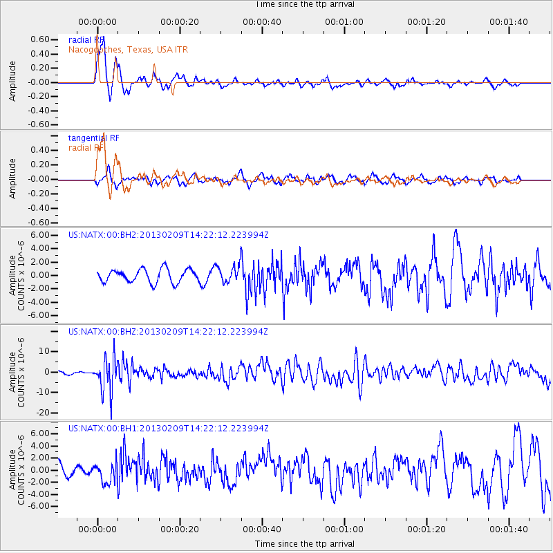
Signal To Noise
| Channel | StoN | STA | LTA |
| US:NATX:00:BHZ:20130209T14:22:12.223994Z | 14.478826 | 8.343373E-6 | 5.762465E-7 |
| US:NATX:00:BH1:20130209T14:22:12.223994Z | 1.6723604 | 1.7012493E-6 | 1.0172743E-6 |
| US:NATX:00:BH2:20130209T14:22:12.223994Z | 1.3080076 | 1.3015182E-6 | 9.950387E-7 |
| Arrivals |
| Ps | 1.6 SECOND |
| PpPs | 5.2 SECOND |
| PsPs/PpSs | 6.8 SECOND |


