You are here: Home > Network List > GS - US Geological Survey Networks Stations List
> Station KAN10 Keim Farm > Earthquake Result Viewer
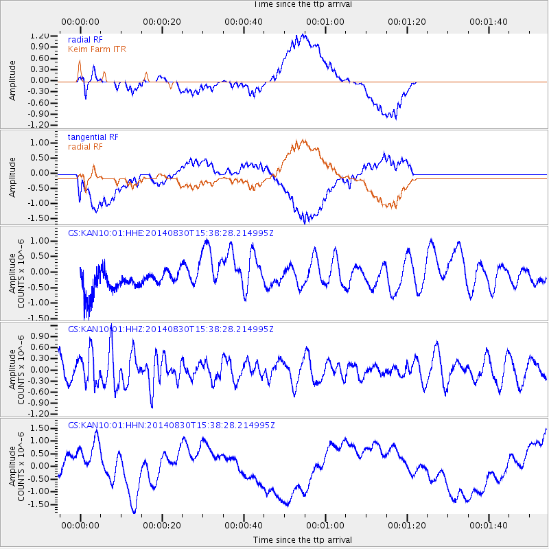
KAN10 Keim Farm - Earthquake Result Viewer
*The percent match for this event was below the threshold and hence no stack was calculated.
| Earthquake location: |
Northern Mid-Atlantic Ridge |
| Earthquake latitude/longitude: |
43.7/-28.5 |
| Earthquake time(UTC): |
2014/08/30 (242) 15:29:50 GMT |
| Earthquake Depth: |
10 km |
| Earthquake Magnitude: |
5.5 MW, 5.3 mb, 5.2 Ms_20, 5.4 Mwb, 5.5 Mwc |
| Earthquake Catalog/Contributor: |
ISC/ISC |
|
| Network: |
GS US Geological Survey Networks |
| Station: |
KAN10 Keim Farm |
| Lat/Lon: |
37.12 N/98.10 W |
| Elevation: |
417 m |
|
| Distance: |
51.9 deg |
| Az: |
287.996 deg |
| Baz: |
59.606 deg |
| Ray Param: |
$rayparam |
*The percent match for this event was below the threshold and hence was not used in the summary stack. |
|
| Radial Match: |
67.96584 % |
| Radial Bump: |
400 |
| Transverse Match: |
54.40287 % |
| Transverse Bump: |
400 |
| SOD ConfigId: |
3390531 |
| Insert Time: |
2019-04-13 17:39:10.924 +0000 |
| GWidth: |
2.5 |
| Max Bumps: |
400 |
| Tol: |
0.001 |
|
Signal To Noise
| Channel | StoN | STA | LTA |
| GS:KAN10:01:HHZ:20140830T15:38:28.214995Z | 1.5621388 | 4.3141773E-7 | 2.761712E-7 |
| GS:KAN10:01:HHN:20140830T15:38:28.214995Z | 1.3381715 | 9.155549E-7 | 6.841835E-7 |
| GS:KAN10:01:HHE:20140830T15:38:28.214995Z | 2.7319655 | 8.360702E-7 | 3.060325E-7 |
| Arrivals |
| Ps | |
| PpPs | |
| PsPs/PpSs | |


