You are here: Home > Network List > US - United States National Seismic Network Stations List
> Station TPNV Topopah Spring, Nevada, USA > Earthquake Result Viewer
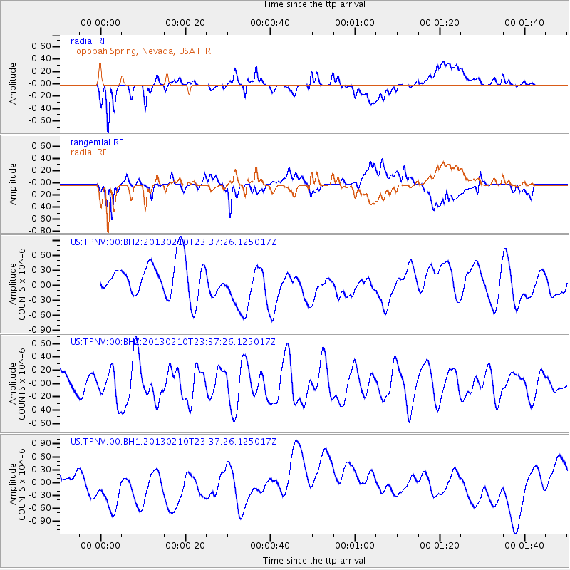
TPNV Topopah Spring, Nevada, USA - Earthquake Result Viewer
*The percent match for this event was below the threshold and hence no stack was calculated.
| Earthquake location: |
Santa Cruz Islands Region |
| Earthquake latitude/longitude: |
-10.7/164.7 |
| Earthquake time(UTC): |
2013/02/10 (041) 23:25:11 GMT |
| Earthquake Depth: |
28 km |
| Earthquake Magnitude: |
5.5 MW |
| Earthquake Catalog/Contributor: |
NEIC PDE/NEIC PDE-W |
|
| Network: |
US United States National Seismic Network |
| Station: |
TPNV Topopah Spring, Nevada, USA |
| Lat/Lon: |
36.95 N/116.25 W |
| Elevation: |
1600 m |
|
| Distance: |
87.7 deg |
| Az: |
51.911 deg |
| Baz: |
254.946 deg |
| Ray Param: |
$rayparam |
*The percent match for this event was below the threshold and hence was not used in the summary stack. |
|
| Radial Match: |
40.34907 % |
| Radial Bump: |
400 |
| Transverse Match: |
37.52198 % |
| Transverse Bump: |
400 |
| SOD ConfigId: |
558545 |
| Insert Time: |
2013-09-18 07:00:41.622 +0000 |
| GWidth: |
2.5 |
| Max Bumps: |
400 |
| Tol: |
0.001 |
|
Signal To Noise
| Channel | StoN | STA | LTA |
| US:TPNV:00:BHZ:20130210T23:37:26.125017Z | 1.1700271 | 2.2708801E-7 | 1.940878E-7 |
| US:TPNV:00:BH1:20130210T23:37:26.125017Z | 3.1093528 | 7.2492315E-7 | 2.3314279E-7 |
| US:TPNV:00:BH2:20130210T23:37:26.125017Z | 1.5442874 | 5.444922E-7 | 3.5258475E-7 |
| Arrivals |
| Ps | |
| PpPs | |
| PsPs/PpSs | |


