You are here: Home > Network List > US - United States National Seismic Network Stations List
> Station HAWA Hanford, Washington, USA > Earthquake Result Viewer
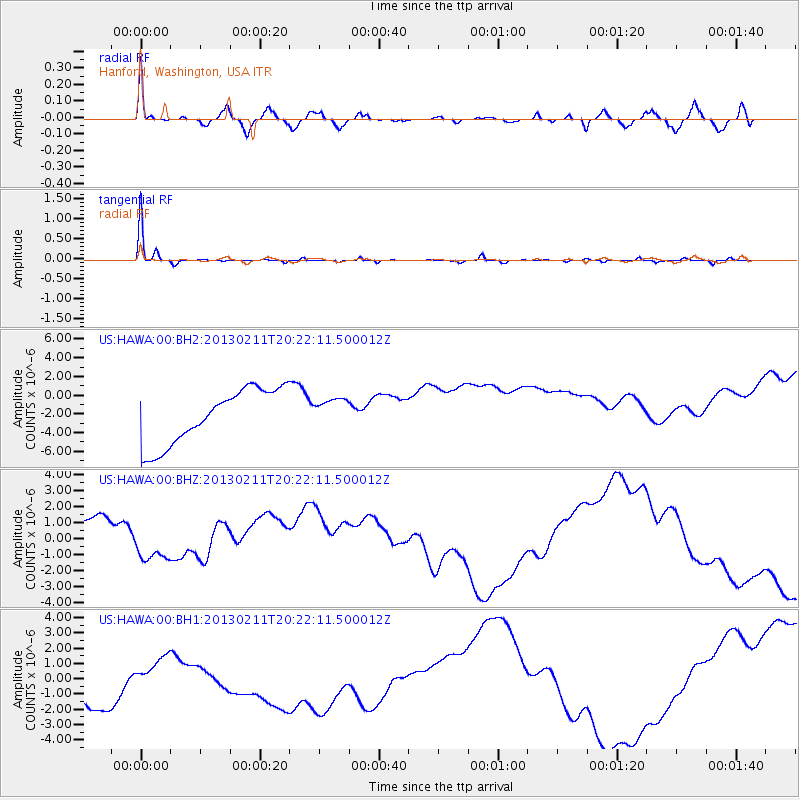
HAWA Hanford, Washington, USA - Earthquake Result Viewer
*The percent match for this event was below the threshold and hence no stack was calculated.
| Earthquake location: |
Santa Cruz Islands |
| Earthquake latitude/longitude: |
-11.0/165.6 |
| Earthquake time(UTC): |
2013/02/11 (042) 20:09:54 GMT |
| Earthquake Depth: |
10 km |
| Earthquake Magnitude: |
5.6 MS, 5.3 MB, 5.7 MW, 5.7 MW |
| Earthquake Catalog/Contributor: |
WHDF/NEIC |
|
| Network: |
US United States National Seismic Network |
| Station: |
HAWA Hanford, Washington, USA |
| Lat/Lon: |
46.39 N/119.53 W |
| Elevation: |
364 m |
|
| Distance: |
87.7 deg |
| Az: |
41.973 deg |
| Baz: |
251.57 deg |
| Ray Param: |
$rayparam |
*The percent match for this event was below the threshold and hence was not used in the summary stack. |
|
| Radial Match: |
92.239296 % |
| Radial Bump: |
400 |
| Transverse Match: |
98.40229 % |
| Transverse Bump: |
159 |
| SOD ConfigId: |
558545 |
| Insert Time: |
2013-09-18 07:05:09.245 +0000 |
| GWidth: |
2.5 |
| Max Bumps: |
400 |
| Tol: |
0.001 |
|
Signal To Noise
| Channel | StoN | STA | LTA |
| US:HAWA:00:BHZ:20130211T20:22:11.500012Z | 0.49404365 | 2.0753978E-6 | 4.2008387E-6 |
| US:HAWA:00:BH1:20130211T20:22:11.500012Z | 0.5317143 | 2.7205967E-6 | 5.116651E-6 |
| US:HAWA:00:BH2:20130211T20:22:11.500012Z | 0.53682214 | 1.5732124E-6 | 2.9306027E-6 |
| Arrivals |
| Ps | |
| PpPs | |
| PsPs/PpSs | |


