You are here: Home > Network List > US - United States National Seismic Network Stations List
> Station WRAK Wrangell Island, Southeastern Alaska, Alaska, USA > Earthquake Result Viewer
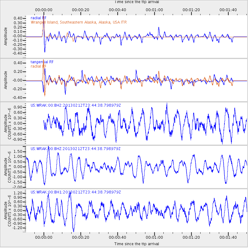
WRAK Wrangell Island, Southeastern Alaska, Alaska, USA - Earthquake Result Viewer
*The percent match for this event was below the threshold and hence no stack was calculated.
| Earthquake location: |
Santa Cruz Islands Region |
| Earthquake latitude/longitude: |
-10.9/164.3 |
| Earthquake time(UTC): |
2013/02/12 (043) 23:32:34 GMT |
| Earthquake Depth: |
9.2 km |
| Earthquake Magnitude: |
5.6 MW, 5.5 MS, 5.5 MW |
| Earthquake Catalog/Contributor: |
NEIC PDE/NEIC PDE-W |
|
| Network: |
US United States National Seismic Network |
| Station: |
WRAK Wrangell Island, Southeastern Alaska, Alaska, USA |
| Lat/Lon: |
56.42 N/132.35 W |
| Elevation: |
81 m |
|
| Distance: |
84.9 deg |
| Az: |
29.922 deg |
| Baz: |
241.844 deg |
| Ray Param: |
$rayparam |
*The percent match for this event was below the threshold and hence was not used in the summary stack. |
|
| Radial Match: |
63.095623 % |
| Radial Bump: |
400 |
| Transverse Match: |
71.55532 % |
| Transverse Bump: |
400 |
| SOD ConfigId: |
558545 |
| Insert Time: |
2013-09-18 07:08:42.551 +0000 |
| GWidth: |
2.5 |
| Max Bumps: |
400 |
| Tol: |
0.001 |
|
Signal To Noise
| Channel | StoN | STA | LTA |
| US:WRAK:00:BHZ:20130212T23:44:38.798979Z | 2.0249481 | 1.1112039E-6 | 5.487567E-7 |
| US:WRAK:00:BH1:20130212T23:44:38.798979Z | 1.5803444 | 6.329206E-7 | 4.0049537E-7 |
| US:WRAK:00:BH2:20130212T23:44:38.798979Z | 0.9236037 | 3.584082E-7 | 3.8805408E-7 |
| Arrivals |
| Ps | |
| PpPs | |
| PsPs/PpSs | |


