You are here: Home > Network List > TA - USArray Transportable Network (new EarthScope stations) Stations List
> Station 833A Chaparral WMA, Artesia Wells, TX, USA > Earthquake Result Viewer
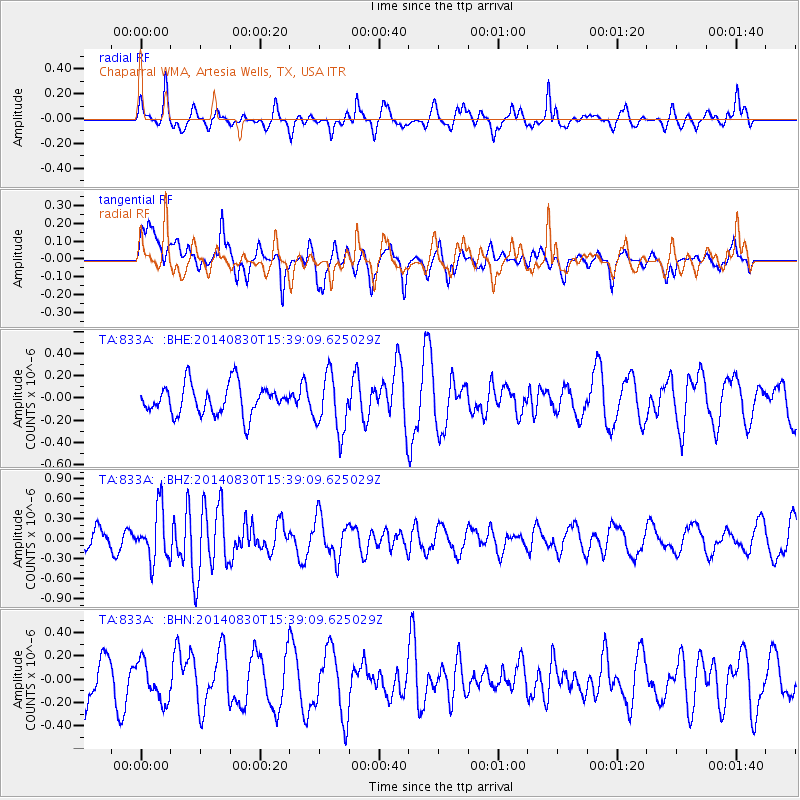
833A Chaparral WMA, Artesia Wells, TX, USA - Earthquake Result Viewer
*The percent match for this event was below the threshold and hence no stack was calculated.
| Earthquake location: |
Northern Mid-Atlantic Ridge |
| Earthquake latitude/longitude: |
43.7/-28.5 |
| Earthquake time(UTC): |
2014/08/30 (242) 15:29:50 GMT |
| Earthquake Depth: |
10 km |
| Earthquake Magnitude: |
5.5 MW, 5.3 mb, 5.2 Ms_20, 5.4 Mwb, 5.5 Mwc |
| Earthquake Catalog/Contributor: |
ISC/ISC |
|
| Network: |
TA USArray Transportable Network (new EarthScope stations) |
| Station: |
833A Chaparral WMA, Artesia Wells, TX, USA |
| Lat/Lon: |
28.32 N/99.39 W |
| Elevation: |
171 m |
|
| Distance: |
57.7 deg |
| Az: |
279.738 deg |
| Baz: |
54.135 deg |
| Ray Param: |
$rayparam |
*The percent match for this event was below the threshold and hence was not used in the summary stack. |
|
| Radial Match: |
53.4896 % |
| Radial Bump: |
354 |
| Transverse Match: |
57.49282 % |
| Transverse Bump: |
400 |
| SOD ConfigId: |
3390531 |
| Insert Time: |
2019-04-13 17:42:22.542 +0000 |
| GWidth: |
2.5 |
| Max Bumps: |
400 |
| Tol: |
0.001 |
|
Signal To Noise
| Channel | StoN | STA | LTA |
| TA:833A: :BHZ:20140830T15:39:09.625029Z | 3.020043 | 3.8782719E-7 | 1.2841777E-7 |
| TA:833A: :BHN:20140830T15:39:09.625029Z | 0.9408934 | 1.663323E-7 | 1.7678123E-7 |
| TA:833A: :BHE:20140830T15:39:09.625029Z | 1.9164234 | 2.5617922E-7 | 1.336757E-7 |
| Arrivals |
| Ps | |
| PpPs | |
| PsPs/PpSs | |


