You are here: Home > Network List > II - Global Seismograph Network (GSN - IRIS/IDA) Stations List
> Station WRAB Tennant Creek, NT, Australia > Earthquake Result Viewer
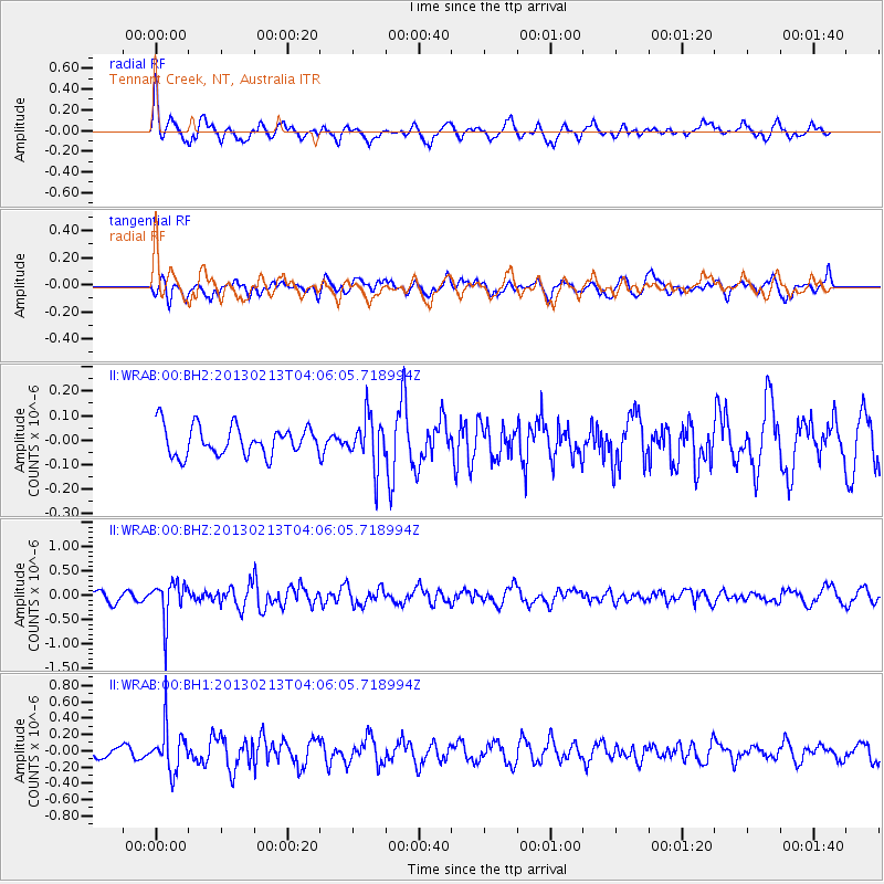
WRAB Tennant Creek, NT, Australia - Earthquake Result Viewer
*The percent match for this event was below the threshold and hence no stack was calculated.
| Earthquake location: |
Kyushu, Japan |
| Earthquake latitude/longitude: |
30.3/131.4 |
| Earthquake time(UTC): |
2013/02/13 (044) 03:57:42 GMT |
| Earthquake Depth: |
10 km |
| Earthquake Magnitude: |
5.5 MB, 5.1 MS, 5.2 MW, 5.4 MW |
| Earthquake Catalog/Contributor: |
WHDF/NEIC |
|
| Network: |
II Global Seismograph Network (GSN - IRIS/IDA) |
| Station: |
WRAB Tennant Creek, NT, Australia |
| Lat/Lon: |
19.93 S/134.36 E |
| Elevation: |
366 m |
|
| Distance: |
50.0 deg |
| Az: |
176.377 deg |
| Baz: |
356.669 deg |
| Ray Param: |
$rayparam |
*The percent match for this event was below the threshold and hence was not used in the summary stack. |
|
| Radial Match: |
73.685326 % |
| Radial Bump: |
400 |
| Transverse Match: |
59.118305 % |
| Transverse Bump: |
400 |
| SOD ConfigId: |
558545 |
| Insert Time: |
2013-09-18 07:09:55.965 +0000 |
| GWidth: |
2.5 |
| Max Bumps: |
400 |
| Tol: |
0.001 |
|
Signal To Noise
| Channel | StoN | STA | LTA |
| II:WRAB:00:BHZ:20130213T04:06:05.718994Z | 4.5274725 | 4.052609E-7 | 8.95115E-8 |
| II:WRAB:00:BH1:20130213T04:06:05.718994Z | 4.115506 | 2.678421E-7 | 6.50812E-8 |
| II:WRAB:00:BH2:20130213T04:06:05.718994Z | 1.69339 | 1.00544575E-7 | 5.937473E-8 |
| Arrivals |
| Ps | |
| PpPs | |
| PsPs/PpSs | |


