You are here: Home > Network List > IU - Global Seismograph Network (GSN - IRIS/USGS) Stations List
> Station CTAO Charters Towers, Australia > Earthquake Result Viewer
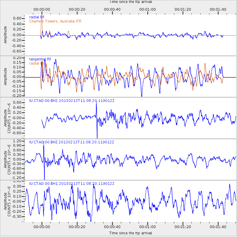
CTAO Charters Towers, Australia - Earthquake Result Viewer
*The percent match for this event was below the threshold and hence no stack was calculated.
| Earthquake location: |
Southern Sumatra, Indonesia |
| Earthquake latitude/longitude: |
-3.0/101.3 |
| Earthquake time(UTC): |
2013/02/13 (044) 11:00:24 GMT |
| Earthquake Depth: |
55 km |
| Earthquake Magnitude: |
5.5 MB, 5.3 MW |
| Earthquake Catalog/Contributor: |
WHDF/NEIC |
|
| Network: |
IU Global Seismograph Network (GSN - IRIS/USGS) |
| Station: |
CTAO Charters Towers, Australia |
| Lat/Lon: |
20.09 S/146.25 E |
| Elevation: |
357 m |
|
| Distance: |
47.0 deg |
| Az: |
114.775 deg |
| Baz: |
285.266 deg |
| Ray Param: |
$rayparam |
*The percent match for this event was below the threshold and hence was not used in the summary stack. |
|
| Radial Match: |
48.78305 % |
| Radial Bump: |
400 |
| Transverse Match: |
60.92104 % |
| Transverse Bump: |
400 |
| SOD ConfigId: |
558545 |
| Insert Time: |
2013-09-18 07:16:23.256 +0000 |
| GWidth: |
2.5 |
| Max Bumps: |
400 |
| Tol: |
0.001 |
|
Signal To Noise
| Channel | StoN | STA | LTA |
| IU:CTAO:00:BHZ:20130213T11:08:20.119012Z | 2.212727 | 3.8719446E-7 | 1.7498517E-7 |
| IU:CTAO:00:BH1:20130213T11:08:20.119012Z | 1.3063024 | 1.5502278E-7 | 1.18672965E-7 |
| IU:CTAO:00:BH2:20130213T11:08:20.119012Z | 2.1914113 | 2.4045232E-7 | 1.09724866E-7 |
| Arrivals |
| Ps | |
| PpPs | |
| PsPs/PpSs | |


