You are here: Home > Network List > IU - Global Seismograph Network (GSN - IRIS/USGS) Stations List
> Station HNR Honiara, Solomon Islands > Earthquake Result Viewer
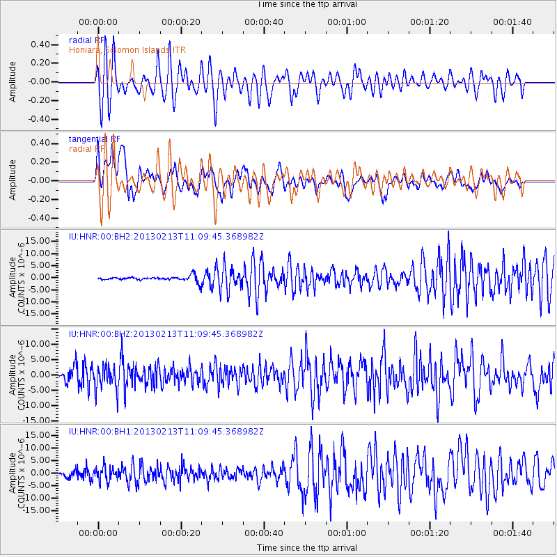
HNR Honiara, Solomon Islands - Earthquake Result Viewer
*The percent match for this event was below the threshold and hence no stack was calculated.
| Earthquake location: |
Southern Sumatra, Indonesia |
| Earthquake latitude/longitude: |
-3.0/101.3 |
| Earthquake time(UTC): |
2013/02/13 (044) 11:00:24 GMT |
| Earthquake Depth: |
55 km |
| Earthquake Magnitude: |
5.5 MB, 5.3 MW |
| Earthquake Catalog/Contributor: |
WHDF/NEIC |
|
| Network: |
IU Global Seismograph Network (GSN - IRIS/USGS) |
| Station: |
HNR Honiara, Solomon Islands |
| Lat/Lon: |
9.44 S/159.95 E |
| Elevation: |
100 m |
|
| Distance: |
58.6 deg |
| Az: |
99.176 deg |
| Baz: |
272.251 deg |
| Ray Param: |
$rayparam |
*The percent match for this event was below the threshold and hence was not used in the summary stack. |
|
| Radial Match: |
66.65234 % |
| Radial Bump: |
400 |
| Transverse Match: |
57.82026 % |
| Transverse Bump: |
400 |
| SOD ConfigId: |
558545 |
| Insert Time: |
2013-09-18 07:16:35.331 +0000 |
| GWidth: |
2.5 |
| Max Bumps: |
400 |
| Tol: |
0.001 |
|
Signal To Noise
| Channel | StoN | STA | LTA |
| IU:HNR:00:BHZ:20130213T11:09:45.368982Z | 3.321363 | 3.9747956E-6 | 1.1967363E-6 |
| IU:HNR:00:BH1:20130213T11:09:45.368982Z | 4.11761 | 2.6426185E-6 | 6.4178454E-7 |
| IU:HNR:00:BH2:20130213T11:09:45.368982Z | 4.8035374 | 4.747823E-6 | 9.884014E-7 |
| Arrivals |
| Ps | |
| PpPs | |
| PsPs/PpSs | |


