You are here: Home > Network List > TA - USArray Transportable Network (new EarthScope stations) Stations List
> Station X43A Marvell, AR, USA > Earthquake Result Viewer
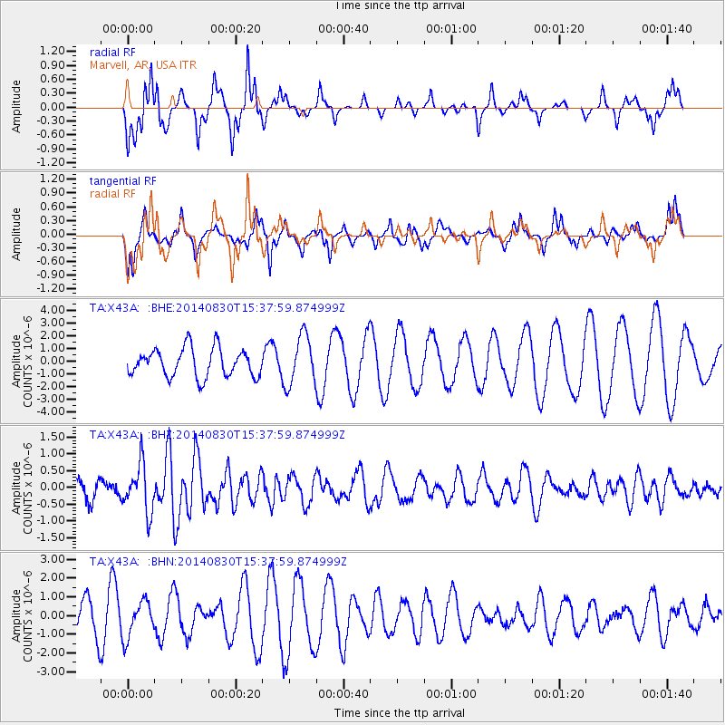
X43A Marvell, AR, USA - Earthquake Result Viewer
*The percent match for this event was below the threshold and hence no stack was calculated.
| Earthquake location: |
Northern Mid-Atlantic Ridge |
| Earthquake latitude/longitude: |
43.7/-28.5 |
| Earthquake time(UTC): |
2014/08/30 (242) 15:29:50 GMT |
| Earthquake Depth: |
10 km |
| Earthquake Magnitude: |
5.5 MW, 5.3 mb, 5.2 Ms_20, 5.4 Mwb, 5.5 Mwc |
| Earthquake Catalog/Contributor: |
ISC/ISC |
|
| Network: |
TA USArray Transportable Network (new EarthScope stations) |
| Station: |
X43A Marvell, AR, USA |
| Lat/Lon: |
34.52 N/90.88 W |
| Elevation: |
53 m |
|
| Distance: |
48.2 deg |
| Az: |
281.201 deg |
| Baz: |
59.449 deg |
| Ray Param: |
$rayparam |
*The percent match for this event was below the threshold and hence was not used in the summary stack. |
|
| Radial Match: |
81.78085 % |
| Radial Bump: |
299 |
| Transverse Match: |
61.105156 % |
| Transverse Bump: |
342 |
| SOD ConfigId: |
3390531 |
| Insert Time: |
2019-04-13 17:43:16.418 +0000 |
| GWidth: |
2.5 |
| Max Bumps: |
400 |
| Tol: |
0.001 |
|
Signal To Noise
| Channel | StoN | STA | LTA |
| TA:X43A: :BHZ:20140830T15:37:59.874999Z | 2.836076 | 7.2984665E-7 | 2.5734383E-7 |
| TA:X43A: :BHN:20140830T15:37:59.874999Z | 0.95131224 | 9.708581E-7 | 1.0205462E-6 |
| TA:X43A: :BHE:20140830T15:37:59.874999Z | 1.7668675 | 1.9532044E-6 | 1.1054617E-6 |
| Arrivals |
| Ps | |
| PpPs | |
| PsPs/PpSs | |


