You are here: Home > Network List > US - United States National Seismic Network Stations List
> Station CBKS Cedar Bluff, Kansas, USA > Earthquake Result Viewer
CBKS Cedar Bluff, Kansas, USA - Earthquake Result Viewer
*The percent match for this event was below the threshold and hence no stack was calculated.
| Earthquake location: |
Northern Mid-Atlantic Ridge |
| Earthquake latitude/longitude: |
43.7/-28.5 |
| Earthquake time(UTC): |
2014/08/30 (242) 15:29:50 GMT |
| Earthquake Depth: |
10 km |
| Earthquake Magnitude: |
5.5 MW, 5.3 mb, 5.2 Ms_20, 5.4 Mwb, 5.5 Mwc |
| Earthquake Catalog/Contributor: |
ISC/ISC |
|
| Network: |
US United States National Seismic Network |
| Station: |
CBKS Cedar Bluff, Kansas, USA |
| Lat/Lon: |
38.81 N/99.74 W |
| Elevation: |
677 m |
|
| Distance: |
52.2 deg |
| Az: |
290.671 deg |
| Baz: |
60.244 deg |
| Ray Param: |
$rayparam |
*The percent match for this event was below the threshold and hence was not used in the summary stack. |
|
| Radial Match: |
69.6713 % |
| Radial Bump: |
400 |
| Transverse Match: |
54.962086 % |
| Transverse Bump: |
299 |
| SOD ConfigId: |
3390531 |
| Insert Time: |
2019-04-13 17:43:44.983 +0000 |
| GWidth: |
2.5 |
| Max Bumps: |
400 |
| Tol: |
0.001 |
|
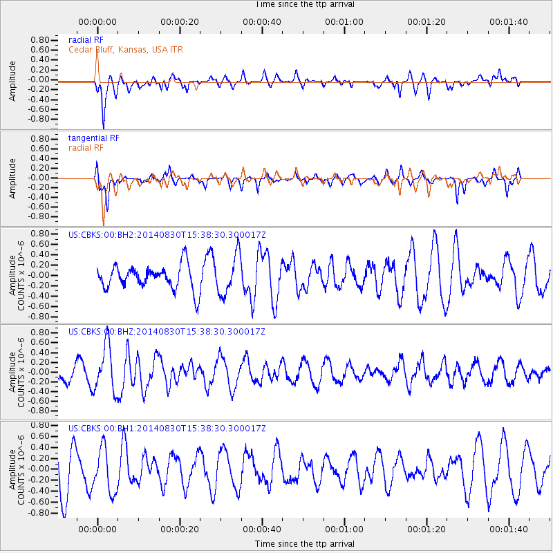
Signal To Noise
| Channel | StoN | STA | LTA |
| US:CBKS:00:BHZ:20140830T15:38:30.300017Z | 3.2174656 | 4.8342775E-7 | 1.5025111E-7 |
| US:CBKS:00:BH1:20140830T15:38:30.300017Z | 0.9755517 | 4.0978918E-7 | 4.2005888E-7 |
| US:CBKS:00:BH2:20140830T15:38:30.300017Z | 1.6605979 | 3.9032707E-7 | 2.3505214E-7 |
| Arrivals |
| Ps | |
| PpPs | |
| PsPs/PpSs | |


