You are here: Home > Network List > US - United States National Seismic Network Stations List
> Station DUG Dugway, Tooele County, Utah, USA > Earthquake Result Viewer
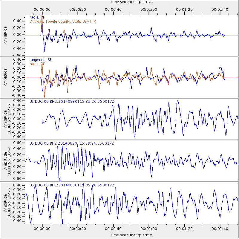
DUG Dugway, Tooele County, Utah, USA - Earthquake Result Viewer
*The percent match for this event was below the threshold and hence no stack was calculated.
| Earthquake location: |
Northern Mid-Atlantic Ridge |
| Earthquake latitude/longitude: |
43.7/-28.5 |
| Earthquake time(UTC): |
2014/08/30 (242) 15:29:50 GMT |
| Earthquake Depth: |
10 km |
| Earthquake Magnitude: |
5.5 MW, 5.3 mb, 5.2 Ms_20, 5.4 Mwb, 5.5 Mwc |
| Earthquake Catalog/Contributor: |
ISC/ISC |
|
| Network: |
US United States National Seismic Network |
| Station: |
DUG Dugway, Tooele County, Utah, USA |
| Lat/Lon: |
40.19 N/112.81 W |
| Elevation: |
1477 m |
|
| Distance: |
60.1 deg |
| Az: |
298.471 deg |
| Baz: |
56.295 deg |
| Ray Param: |
$rayparam |
*The percent match for this event was below the threshold and hence was not used in the summary stack. |
|
| Radial Match: |
62.463104 % |
| Radial Bump: |
400 |
| Transverse Match: |
50.838196 % |
| Transverse Bump: |
378 |
| SOD ConfigId: |
3390531 |
| Insert Time: |
2019-04-13 17:43:47.224 +0000 |
| GWidth: |
2.5 |
| Max Bumps: |
400 |
| Tol: |
0.001 |
|
Signal To Noise
| Channel | StoN | STA | LTA |
| US:DUG:00:BHZ:20140830T15:39:26.550017Z | 2.5964139 | 2.3282303E-7 | 8.9671E-8 |
| US:DUG:00:BH1:20140830T15:39:26.550017Z | 1.4882503 | 2.269145E-7 | 1.5247066E-7 |
| US:DUG:00:BH2:20140830T15:39:26.550017Z | 0.7579519 | 7.390364E-8 | 9.750439E-8 |
| Arrivals |
| Ps | |
| PpPs | |
| PsPs/PpSs | |


