You are here: Home > Network List > US - United States National Seismic Network Stations List
> Station GLMI Grayling, Michigan, USA > Earthquake Result Viewer
GLMI Grayling, Michigan, USA - Earthquake Result Viewer
| Earthquake location: |
Eastern Siberia, Russia |
| Earthquake latitude/longitude: |
67.6/142.5 |
| Earthquake time(UTC): |
2013/02/14 (045) 13:13:53 GMT |
| Earthquake Depth: |
11 km |
| Earthquake Magnitude: |
6.5 MB, 6.7 MS, 6.6 MW, 6.7 MW |
| Earthquake Catalog/Contributor: |
WHDF/NEIC |
|
| Network: |
US United States National Seismic Network |
| Station: |
GLMI Grayling, Michigan, USA |
| Lat/Lon: |
44.82 N/84.62 W |
| Elevation: |
387 m |
|
| Distance: |
62.4 deg |
| Az: |
36.06 deg |
| Baz: |
341.542 deg |
| Ray Param: |
0.060267333 |
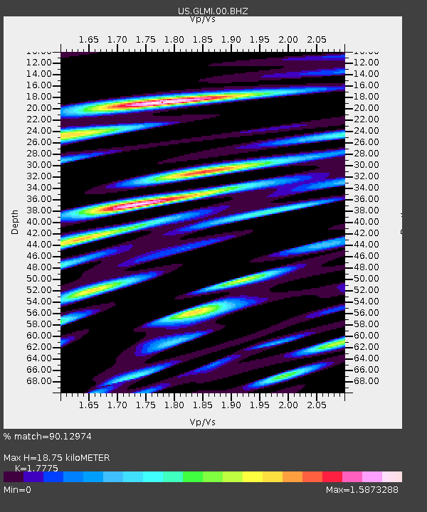
| Estimated Moho Depth: |
18.75 km |
| Estimated Crust Vp/Vs: |
1.78 |
| Assumed Crust Vp: |
6.483 km/s |
| Estimated Crust Vs: |
3.647 km/s |
| Estimated Crust Poisson's Ratio: |
0.27 |
|
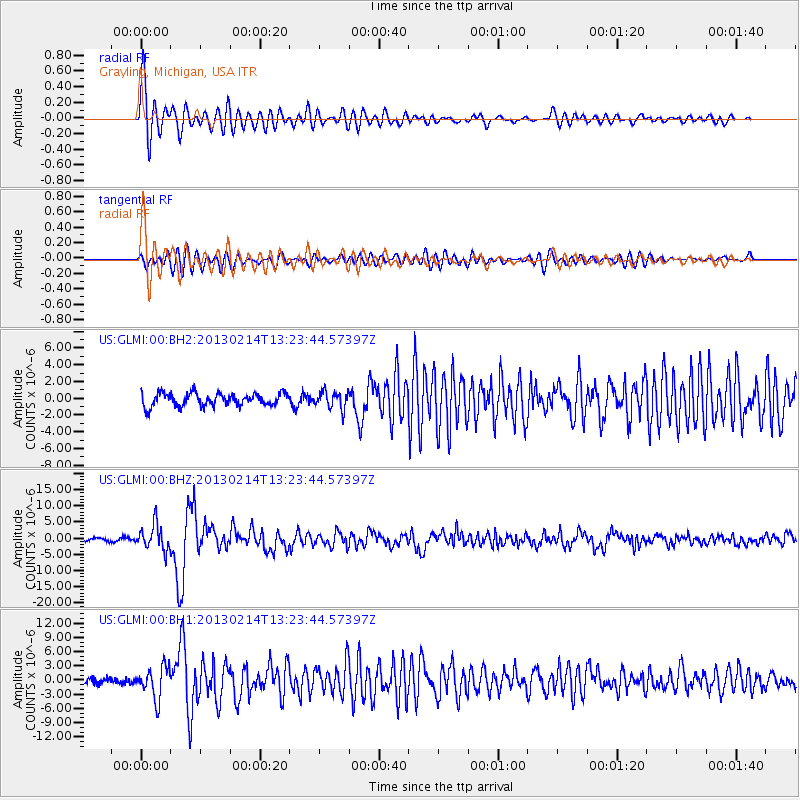
| Radial Match: |
90.12974 % |
| Radial Bump: |
400 |
| Transverse Match: |
74.16065 % |
| Transverse Bump: |
400 |
| SOD ConfigId: |
558545 |
| Insert Time: |
2013-09-18 07:21:57.903 +0000 |
| GWidth: |
2.5 |
| Max Bumps: |
400 |
| Tol: |
0.001 |
|
Signal To Noise
| Channel | StoN | STA | LTA |
| US:GLMI:00:BHZ:20130214T13:23:44.57397Z | 6.9736714 | 3.881868E-6 | 5.566462E-7 |
| US:GLMI:00:BH1:20130214T13:23:44.57397Z | 4.9554276 | 3.355367E-6 | 6.771095E-7 |
| US:GLMI:00:BH2:20130214T13:23:44.57397Z | 1.345843 | 1.0352613E-6 | 7.692289E-7 |
| Arrivals |
| Ps | 2.4 SECOND |
| PpPs | 7.7 SECOND |
| PsPs/PpSs | 10 SECOND |


