You are here: Home > Network List > US - United States National Seismic Network Stations List
> Station RLMT Red Lodge, Montana, USA > Earthquake Result Viewer
RLMT Red Lodge, Montana, USA - Earthquake Result Viewer
| Earthquake location: |
Eastern Siberia, Russia |
| Earthquake latitude/longitude: |
67.6/142.5 |
| Earthquake time(UTC): |
2013/02/14 (045) 13:13:53 GMT |
| Earthquake Depth: |
11 km |
| Earthquake Magnitude: |
6.5 MB, 6.7 MS, 6.6 MW, 6.7 MW |
| Earthquake Catalog/Contributor: |
WHDF/NEIC |
|
| Network: |
US United States National Seismic Network |
| Station: |
RLMT Red Lodge, Montana, USA |
| Lat/Lon: |
45.12 N/109.27 W |
| Elevation: |
2086 m |
|
| Distance: |
55.4 deg |
| Az: |
54.771 deg |
| Baz: |
333.792 deg |
| Ray Param: |
0.06480941 |
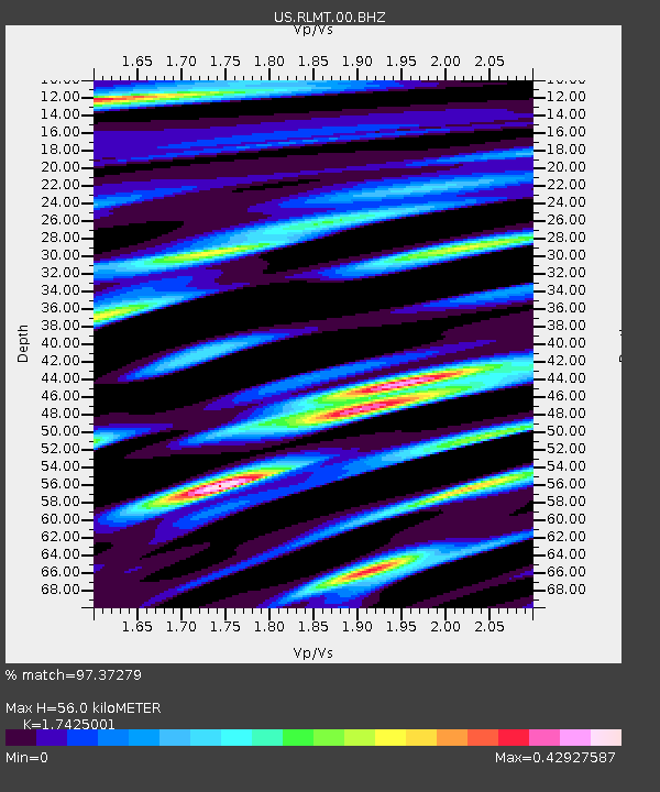
| Estimated Moho Depth: |
56.0 km |
| Estimated Crust Vp/Vs: |
1.74 |
| Assumed Crust Vp: |
6.242 km/s |
| Estimated Crust Vs: |
3.582 km/s |
| Estimated Crust Poisson's Ratio: |
0.25 |
|
| Radial Match: |
97.37279 % |
| Radial Bump: |
323 |
| Transverse Match: |
92.78701 % |
| Transverse Bump: |
400 |
| SOD ConfigId: |
558545 |
| Insert Time: |
2013-09-18 07:23:15.876 +0000 |
| GWidth: |
2.5 |
| Max Bumps: |
400 |
| Tol: |
0.001 |
|

Signal To Noise
| Channel | StoN | STA | LTA |
| US:RLMT:00:BHZ:20130214T13:22:56.299006Z | 7.0512705 | 1.6478348E-6 | 2.336933E-7 |
| US:RLMT:00:BH1:20130214T13:22:56.299006Z | 3.2071557 | 6.68065E-7 | 2.0830453E-7 |
| US:RLMT:00:BH2:20130214T13:22:56.299006Z | 1.735573 | 4.7170215E-7 | 2.7178467E-7 |
| Arrivals |
| Ps | 7.0 SECOND |
| PpPs | 23 SECOND |
| PsPs/PpSs | 30 SECOND |


