You are here: Home > Network List > IU - Global Seismograph Network (GSN - IRIS/USGS) Stations List
> Station RSSD Black Hills, South Dakota, USA > Earthquake Result Viewer
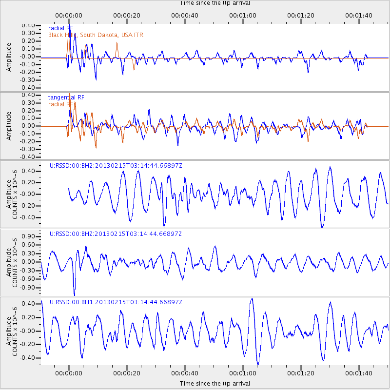
RSSD Black Hills, South Dakota, USA - Earthquake Result Viewer
*The percent match for this event was below the threshold and hence no stack was calculated.
| Earthquake location: |
Tonga Islands |
| Earthquake latitude/longitude: |
-19.7/-174.5 |
| Earthquake time(UTC): |
2013/02/15 (046) 03:02:23 GMT |
| Earthquake Depth: |
74 km |
| Earthquake Magnitude: |
5.8 MB, 5.7 MW, 5.8 MW |
| Earthquake Catalog/Contributor: |
WHDF/NEIC |
|
| Network: |
IU Global Seismograph Network (GSN - IRIS/USGS) |
| Station: |
RSSD Black Hills, South Dakota, USA |
| Lat/Lon: |
44.12 N/104.04 W |
| Elevation: |
2090 m |
|
| Distance: |
90.3 deg |
| Az: |
42.735 deg |
| Baz: |
242.573 deg |
| Ray Param: |
$rayparam |
*The percent match for this event was below the threshold and hence was not used in the summary stack. |
|
| Radial Match: |
62.33129 % |
| Radial Bump: |
400 |
| Transverse Match: |
53.94355 % |
| Transverse Bump: |
381 |
| SOD ConfigId: |
558545 |
| Insert Time: |
2013-09-18 07:25:37.279 +0000 |
| GWidth: |
2.5 |
| Max Bumps: |
400 |
| Tol: |
0.001 |
|
Signal To Noise
| Channel | StoN | STA | LTA |
| IU:RSSD:00:BHZ:20130215T03:14:44.66897Z | 1.9092954 | 4.0085462E-7 | 2.0994898E-7 |
| IU:RSSD:00:BH1:20130215T03:14:44.66897Z | 0.8170073 | 2.0098712E-7 | 2.4600408E-7 |
| IU:RSSD:00:BH2:20130215T03:14:44.66897Z | 1.3297006 | 2.7422334E-7 | 2.0622939E-7 |
| Arrivals |
| Ps | |
| PpPs | |
| PsPs/PpSs | |


