You are here: Home > Network List > US - United States National Seismic Network Stations List
> Station BOZ Bozeman, Montana, USA > Earthquake Result Viewer
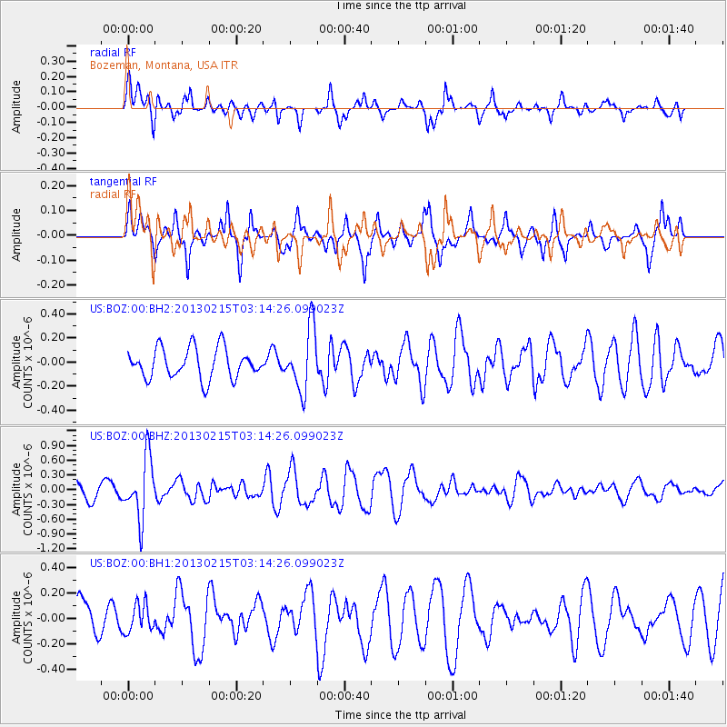
BOZ Bozeman, Montana, USA - Earthquake Result Viewer
*The percent match for this event was below the threshold and hence no stack was calculated.
| Earthquake location: |
Tonga Islands |
| Earthquake latitude/longitude: |
-19.7/-174.5 |
| Earthquake time(UTC): |
2013/02/15 (046) 03:02:23 GMT |
| Earthquake Depth: |
74 km |
| Earthquake Magnitude: |
5.8 MB, 5.7 MW, 5.8 MW |
| Earthquake Catalog/Contributor: |
WHDF/NEIC |
|
| Network: |
US United States National Seismic Network |
| Station: |
BOZ Bozeman, Montana, USA |
| Lat/Lon: |
45.65 N/111.63 W |
| Elevation: |
1589 m |
|
| Distance: |
86.4 deg |
| Az: |
38.706 deg |
| Baz: |
237.113 deg |
| Ray Param: |
$rayparam |
*The percent match for this event was below the threshold and hence was not used in the summary stack. |
|
| Radial Match: |
50.44411 % |
| Radial Bump: |
336 |
| Transverse Match: |
57.349632 % |
| Transverse Bump: |
295 |
| SOD ConfigId: |
558545 |
| Insert Time: |
2013-09-18 07:26:11.592 +0000 |
| GWidth: |
2.5 |
| Max Bumps: |
400 |
| Tol: |
0.001 |
|
Signal To Noise
| Channel | StoN | STA | LTA |
| US:BOZ:00:BHZ:20130215T03:14:26.099023Z | 2.7855783 | 6.1536633E-7 | 2.2091153E-7 |
| US:BOZ:00:BH1:20130215T03:14:26.099023Z | 0.51316744 | 1.10891044E-7 | 2.1609134E-7 |
| US:BOZ:00:BH2:20130215T03:14:26.099023Z | 2.1236055 | 2.6402145E-7 | 1.2432697E-7 |
| Arrivals |
| Ps | |
| PpPs | |
| PsPs/PpSs | |


