You are here: Home > Network List > US - United States National Seismic Network Stations List
> Station MVCO Mesa Verde, Colorado, USA > Earthquake Result Viewer
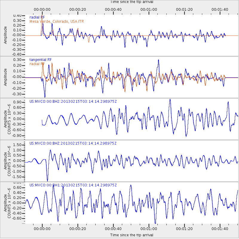
MVCO Mesa Verde, Colorado, USA - Earthquake Result Viewer
*The percent match for this event was below the threshold and hence no stack was calculated.
| Earthquake location: |
Tonga Islands |
| Earthquake latitude/longitude: |
-19.7/-174.5 |
| Earthquake time(UTC): |
2013/02/15 (046) 03:02:23 GMT |
| Earthquake Depth: |
74 km |
| Earthquake Magnitude: |
5.8 MB, 5.7 MW, 5.8 MW |
| Earthquake Catalog/Contributor: |
WHDF/NEIC |
|
| Network: |
US United States National Seismic Network |
| Station: |
MVCO Mesa Verde, Colorado, USA |
| Lat/Lon: |
37.21 N/108.50 W |
| Elevation: |
2170 m |
|
| Distance: |
84.0 deg |
| Az: |
47.151 deg |
| Baz: |
239.888 deg |
| Ray Param: |
$rayparam |
*The percent match for this event was below the threshold and hence was not used in the summary stack. |
|
| Radial Match: |
59.912548 % |
| Radial Bump: |
400 |
| Transverse Match: |
60.305843 % |
| Transverse Bump: |
400 |
| SOD ConfigId: |
558545 |
| Insert Time: |
2013-09-18 07:27:00.385 +0000 |
| GWidth: |
2.5 |
| Max Bumps: |
400 |
| Tol: |
0.001 |
|
Signal To Noise
| Channel | StoN | STA | LTA |
| US:MVCO:00:BHZ:20130215T03:14:14.298975Z | 3.9553773 | 7.319124E-7 | 1.8504237E-7 |
| US:MVCO:00:BH1:20130215T03:14:14.298975Z | 1.50811 | 3.0869523E-7 | 2.0469012E-7 |
| US:MVCO:00:BH2:20130215T03:14:14.298975Z | 1.3607565 | 2.5659466E-7 | 1.8856765E-7 |
| Arrivals |
| Ps | |
| PpPs | |
| PsPs/PpSs | |


