You are here: Home > Network List > IU - Global Seismograph Network (GSN - IRIS/USGS) Stations List
> Station HNR Honiara, Solomon Islands > Earthquake Result Viewer
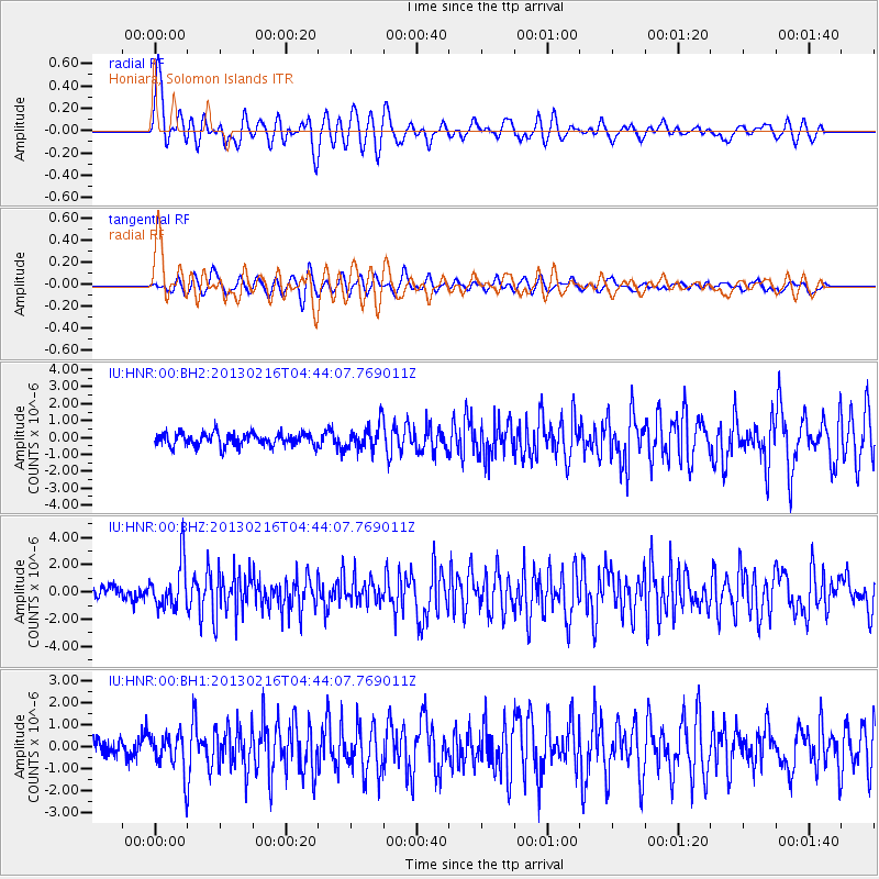
HNR Honiara, Solomon Islands - Earthquake Result Viewer
*The percent match for this event was below the threshold and hence no stack was calculated.
| Earthquake location: |
Mindanao, Philippines |
| Earthquake latitude/longitude: |
5.8/125.7 |
| Earthquake time(UTC): |
2013/02/16 (047) 04:37:36 GMT |
| Earthquake Depth: |
105 km |
| Earthquake Magnitude: |
5.9 MB, 6.1 MW, 6.2 MW |
| Earthquake Catalog/Contributor: |
WHDF/NEIC |
|
| Network: |
IU Global Seismograph Network (GSN - IRIS/USGS) |
| Station: |
HNR Honiara, Solomon Islands |
| Lat/Lon: |
9.44 S/159.95 E |
| Elevation: |
100 m |
|
| Distance: |
37.3 deg |
| Az: |
113.765 deg |
| Baz: |
292.647 deg |
| Ray Param: |
$rayparam |
*The percent match for this event was below the threshold and hence was not used in the summary stack. |
|
| Radial Match: |
75.207634 % |
| Radial Bump: |
400 |
| Transverse Match: |
69.38271 % |
| Transverse Bump: |
400 |
| SOD ConfigId: |
558545 |
| Insert Time: |
2013-09-18 07:28:33.109 +0000 |
| GWidth: |
2.5 |
| Max Bumps: |
400 |
| Tol: |
0.001 |
|
Signal To Noise
| Channel | StoN | STA | LTA |
| IU:HNR:00:BHZ:20130216T04:44:07.769011Z | 3.316661 | 1.6428274E-6 | 4.953257E-7 |
| IU:HNR:00:BH1:20130216T04:44:07.769011Z | 2.1948628 | 8.973157E-7 | 4.088254E-7 |
| IU:HNR:00:BH2:20130216T04:44:07.769011Z | 2.0276012 | 7.5245305E-7 | 3.7110505E-7 |
| Arrivals |
| Ps | |
| PpPs | |
| PsPs/PpSs | |


