You are here: Home > Network List > IU - Global Seismograph Network (GSN - IRIS/USGS) Stations List
> Station CTAO Charters Towers, Australia > Earthquake Result Viewer
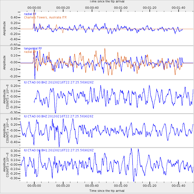
CTAO Charters Towers, Australia - Earthquake Result Viewer
*The percent match for this event was below the threshold and hence no stack was calculated.
| Earthquake location: |
Kuril Islands |
| Earthquake latitude/longitude: |
43.5/146.7 |
| Earthquake time(UTC): |
2013/02/16 (047) 22:17:32 GMT |
| Earthquake Depth: |
46 km |
| Earthquake Magnitude: |
5.6 MB, 5.1 MS, 5.3 MW, 5.4 MW |
| Earthquake Catalog/Contributor: |
WHDF/NEIC |
|
| Network: |
IU Global Seismograph Network (GSN - IRIS/USGS) |
| Station: |
CTAO Charters Towers, Australia |
| Lat/Lon: |
20.09 S/146.25 E |
| Elevation: |
357 m |
|
| Distance: |
63.3 deg |
| Az: |
180.442 deg |
| Baz: |
0.342 deg |
| Ray Param: |
$rayparam |
*The percent match for this event was below the threshold and hence was not used in the summary stack. |
|
| Radial Match: |
58.02808 % |
| Radial Bump: |
400 |
| Transverse Match: |
45.324955 % |
| Transverse Bump: |
400 |
| SOD ConfigId: |
558545 |
| Insert Time: |
2013-09-18 07:31:58.119 +0000 |
| GWidth: |
2.5 |
| Max Bumps: |
400 |
| Tol: |
0.001 |
|
Signal To Noise
| Channel | StoN | STA | LTA |
| IU:CTAO:00:BHZ:20130216T22:27:25.569026Z | 1.5522475 | 2.2465561E-7 | 1.4472924E-7 |
| IU:CTAO:00:BH1:20130216T22:27:25.569026Z | 1.7779752 | 1.7873033E-7 | 1.00524645E-7 |
| IU:CTAO:00:BH2:20130216T22:27:25.569026Z | 0.6722782 | 6.722022E-8 | 9.998868E-8 |
| Arrivals |
| Ps | |
| PpPs | |
| PsPs/PpSs | |


