You are here: Home > Network List > IU - Global Seismograph Network (GSN - IRIS/USGS) Stations List
> Station JOHN Johnston Island, USA > Earthquake Result Viewer
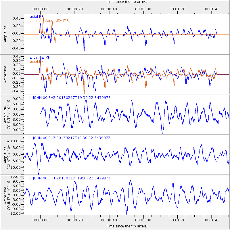
JOHN Johnston Island, USA - Earthquake Result Viewer
*The percent match for this event was below the threshold and hence no stack was calculated.
| Earthquake location: |
Santa Cruz Islands |
| Earthquake latitude/longitude: |
-10.8/165.6 |
| Earthquake time(UTC): |
2013/02/17 (048) 19:23:45 GMT |
| Earthquake Depth: |
10 km |
| Earthquake Magnitude: |
5.7 MW, 5.6 MW |
| Earthquake Catalog/Contributor: |
NEIC PDE/NEIC PDE-W |
|
| Network: |
IU Global Seismograph Network (GSN - IRIS/USGS) |
| Station: |
JOHN Johnston Island, USA |
| Lat/Lon: |
16.73 N/169.53 W |
| Elevation: |
2.0 m |
|
| Distance: |
36.8 deg |
| Az: |
42.338 deg |
| Baz: |
223.677 deg |
| Ray Param: |
$rayparam |
*The percent match for this event was below the threshold and hence was not used in the summary stack. |
|
| Radial Match: |
41.787067 % |
| Radial Bump: |
348 |
| Transverse Match: |
56.404697 % |
| Transverse Bump: |
400 |
| SOD ConfigId: |
558545 |
| Insert Time: |
2013-09-18 07:36:44.121 +0000 |
| GWidth: |
2.5 |
| Max Bumps: |
400 |
| Tol: |
0.001 |
|
Signal To Noise
| Channel | StoN | STA | LTA |
| IU:JOHN:00:BHZ:20130217T19:30:22.343997Z | 3.31219 | 5.961714E-6 | 1.7999313E-6 |
| IU:JOHN:00:BH1:20130217T19:30:22.343997Z | 0.955123 | 2.609502E-6 | 2.732111E-6 |
| IU:JOHN:00:BH2:20130217T19:30:22.343997Z | 1.1210347 | 4.2819943E-6 | 3.81968E-6 |
| Arrivals |
| Ps | |
| PpPs | |
| PsPs/PpSs | |


