You are here: Home > Network List > II - Global Seismograph Network (GSN - IRIS/IDA) Stations List
> Station WRAB Tennant Creek, NT, Australia > Earthquake Result Viewer
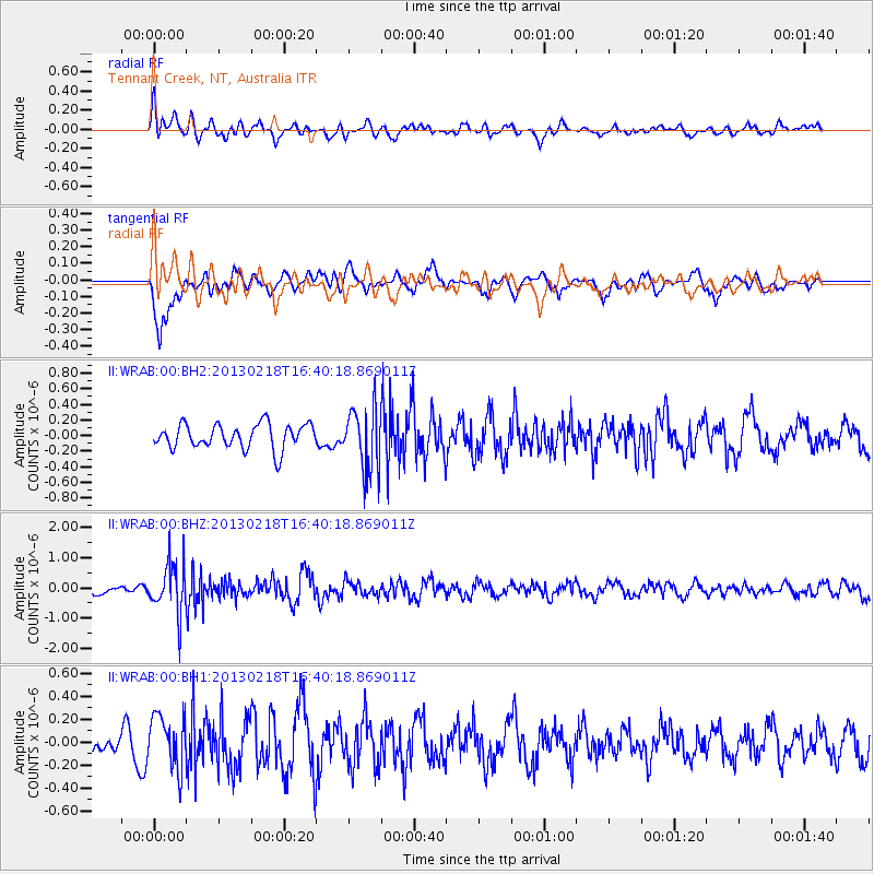
WRAB Tennant Creek, NT, Australia - Earthquake Result Viewer
*The percent match for this event was below the threshold and hence no stack was calculated.
| Earthquake location: |
Kermadec Islands, New Zealand |
| Earthquake latitude/longitude: |
-30.7/-178.1 |
| Earthquake time(UTC): |
2013/02/18 (049) 16:32:47 GMT |
| Earthquake Depth: |
50 km |
| Earthquake Magnitude: |
5.6 MB, 5.5 MW, 5.5 MW |
| Earthquake Catalog/Contributor: |
WHDF/NEIC |
|
| Network: |
II Global Seismograph Network (GSN - IRIS/IDA) |
| Station: |
WRAB Tennant Creek, NT, Australia |
| Lat/Lon: |
19.93 S/134.36 E |
| Elevation: |
366 m |
|
| Distance: |
44.0 deg |
| Az: |
272.606 deg |
| Baz: |
113.911 deg |
| Ray Param: |
$rayparam |
*The percent match for this event was below the threshold and hence was not used in the summary stack. |
|
| Radial Match: |
62.490448 % |
| Radial Bump: |
400 |
| Transverse Match: |
61.00545 % |
| Transverse Bump: |
400 |
| SOD ConfigId: |
558545 |
| Insert Time: |
2013-09-18 07:43:44.187 +0000 |
| GWidth: |
2.5 |
| Max Bumps: |
400 |
| Tol: |
0.001 |
|
Signal To Noise
| Channel | StoN | STA | LTA |
| II:WRAB:00:BHZ:20130218T16:40:18.869011Z | 4.172833 | 8.2822277E-7 | 1.9847974E-7 |
| II:WRAB:00:BH1:20130218T16:40:18.869011Z | 1.7581697 | 2.327949E-7 | 1.3240754E-7 |
| II:WRAB:00:BH2:20130218T16:40:18.869011Z | 2.4802282 | 3.8944933E-7 | 1.5702159E-7 |
| Arrivals |
| Ps | |
| PpPs | |
| PsPs/PpSs | |


