You are here: Home > Network List > US - United States National Seismic Network Stations List
> Station WUAZ Wupatki, Arizona, USA > Earthquake Result Viewer
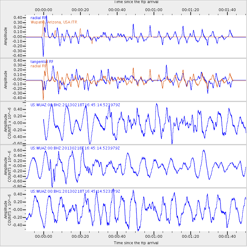
WUAZ Wupatki, Arizona, USA - Earthquake Result Viewer
*The percent match for this event was below the threshold and hence no stack was calculated.
| Earthquake location: |
Kermadec Islands, New Zealand |
| Earthquake latitude/longitude: |
-30.7/-178.1 |
| Earthquake time(UTC): |
2013/02/18 (049) 16:32:47 GMT |
| Earthquake Depth: |
50 km |
| Earthquake Magnitude: |
5.6 MB, 5.5 MW, 5.5 MW |
| Earthquake Catalog/Contributor: |
WHDF/NEIC |
|
| Network: |
US United States National Seismic Network |
| Station: |
WUAZ Wupatki, Arizona, USA |
| Lat/Lon: |
35.52 N/111.37 W |
| Elevation: |
1592 m |
|
| Distance: |
91.0 deg |
| Az: |
48.571 deg |
| Baz: |
232.308 deg |
| Ray Param: |
$rayparam |
*The percent match for this event was below the threshold and hence was not used in the summary stack. |
|
| Radial Match: |
51.36961 % |
| Radial Bump: |
400 |
| Transverse Match: |
60.235767 % |
| Transverse Bump: |
400 |
| SOD ConfigId: |
558545 |
| Insert Time: |
2013-09-18 07:44:48.825 +0000 |
| GWidth: |
2.5 |
| Max Bumps: |
400 |
| Tol: |
0.001 |
|
Signal To Noise
| Channel | StoN | STA | LTA |
| US:WUAZ:00:BHZ:20130218T16:45:14.523979Z | 1.4788989 | 3.917781E-7 | 2.6491202E-7 |
| US:WUAZ:00:BH1:20130218T16:45:14.523979Z | 1.2835974 | 2.9346575E-7 | 2.2862757E-7 |
| US:WUAZ:00:BH2:20130218T16:45:14.523979Z | 0.44588047 | 1.3104099E-7 | 2.9389264E-7 |
| Arrivals |
| Ps | |
| PpPs | |
| PsPs/PpSs | |


