You are here: Home > Network List > US - United States National Seismic Network Stations List
> Station DGMT Dagmar, Montana, USA > Earthquake Result Viewer
DGMT Dagmar, Montana, USA - Earthquake Result Viewer
*The percent match for this event was below the threshold and hence no stack was calculated.
| Earthquake location: |
Tonga Islands |
| Earthquake latitude/longitude: |
-17.5/-173.5 |
| Earthquake time(UTC): |
2013/02/19 (050) 22:29:02 GMT |
| Earthquake Depth: |
47 km |
| Earthquake Magnitude: |
5.7 MB, 5.3 MS, 5.7 MW, 5.8 MW |
| Earthquake Catalog/Contributor: |
WHDF/NEIC |
|
| Network: |
US United States National Seismic Network |
| Station: |
DGMT Dagmar, Montana, USA |
| Lat/Lon: |
48.47 N/104.20 W |
| Elevation: |
0.0 m |
|
| Distance: |
89.9 deg |
| Az: |
38.489 deg |
| Baz: |
243.205 deg |
| Ray Param: |
$rayparam |
*The percent match for this event was below the threshold and hence was not used in the summary stack. |
|
| Radial Match: |
52.212822 % |
| Radial Bump: |
350 |
| Transverse Match: |
57.401936 % |
| Transverse Bump: |
301 |
| SOD ConfigId: |
558545 |
| Insert Time: |
2013-09-18 07:50:19.848 +0000 |
| GWidth: |
2.5 |
| Max Bumps: |
400 |
| Tol: |
0.001 |
|
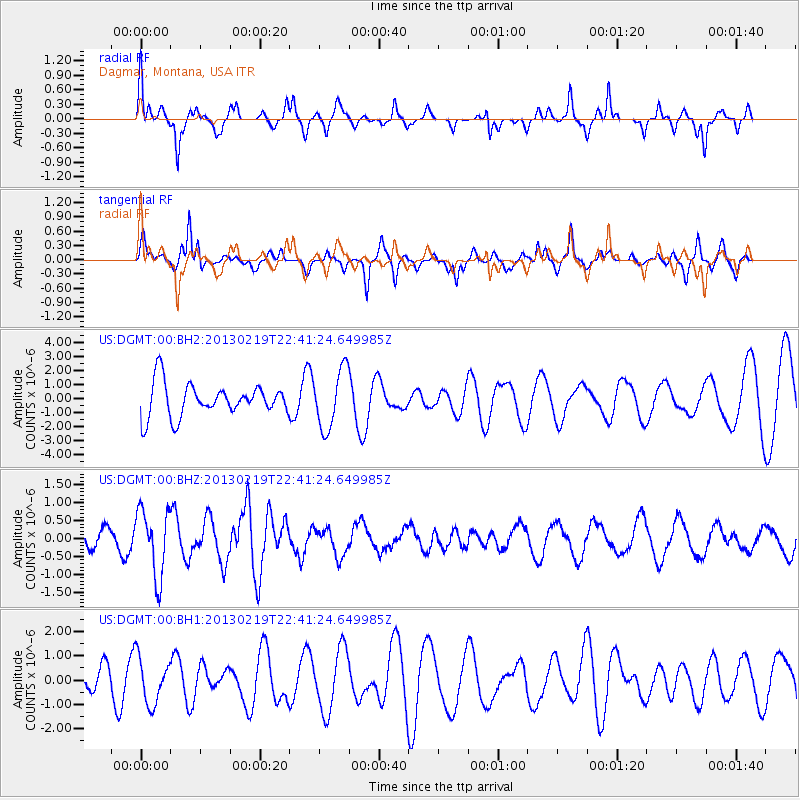
Signal To Noise
| Channel | StoN | STA | LTA |
| US:DGMT:00:BHZ:20130219T22:41:24.649985Z | 3.168426 | 9.340635E-7 | 2.9480364E-7 |
| US:DGMT:00:BH1:20130219T22:41:24.649985Z | 1.1433786 | 9.39215E-7 | 8.2143833E-7 |
| US:DGMT:00:BH2:20130219T22:41:24.649985Z | 1.7882026 | 2.0982743E-6 | 1.1733985E-6 |
| Arrivals |
| Ps | |
| PpPs | |
| PsPs/PpSs | |


