You are here: Home > Network List > TA - USArray Transportable Network (new EarthScope stations) Stations List
> Station R11A Troy Canyon, Currant, NV, USA > Earthquake Result Viewer
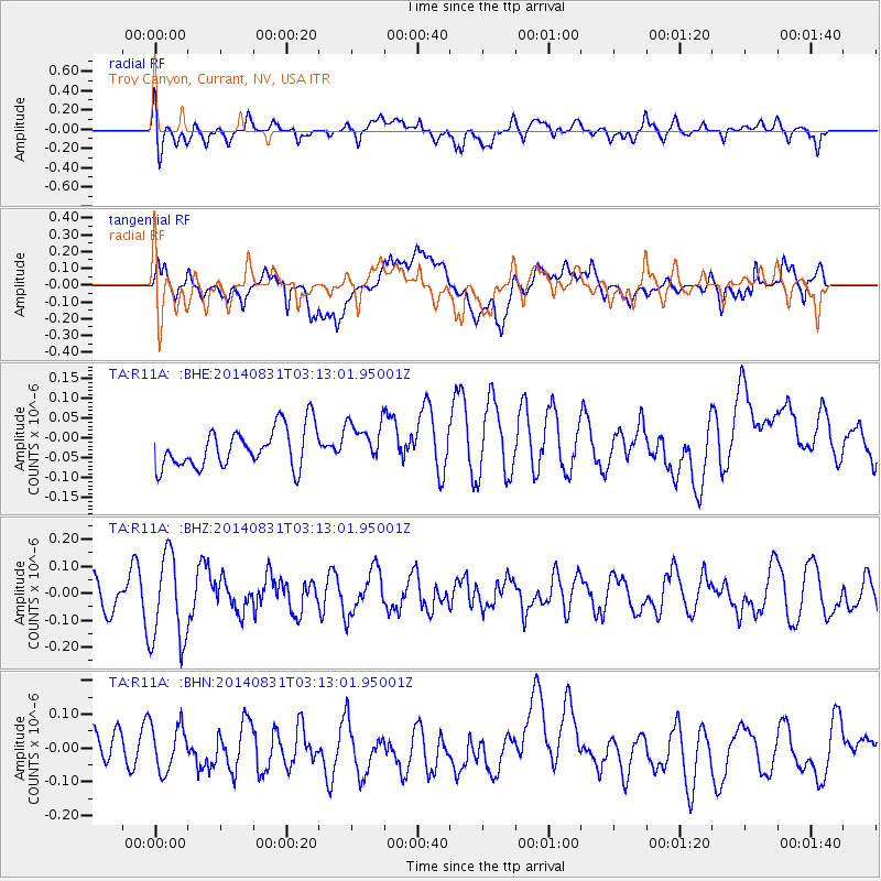
R11A Troy Canyon, Currant, NV, USA - Earthquake Result Viewer
*The percent match for this event was below the threshold and hence no stack was calculated.
| Earthquake location: |
Northern Alaska |
| Earthquake latitude/longitude: |
65.2/-149.0 |
| Earthquake time(UTC): |
2014/08/31 (243) 03:06:57 GMT |
| Earthquake Depth: |
16 km |
| Earthquake Magnitude: |
5.1 Mww, 5.1 ML, 4.9 mb, 4.8 Ms_20, 5.0 Mwr |
| Earthquake Catalog/Contributor: |
ISC/ISC |
|
| Network: |
TA USArray Transportable Network (new EarthScope stations) |
| Station: |
R11A Troy Canyon, Currant, NV, USA |
| Lat/Lon: |
38.35 N/115.59 W |
| Elevation: |
1756 m |
|
| Distance: |
33.2 deg |
| Az: |
127.579 deg |
| Baz: |
334.792 deg |
| Ray Param: |
$rayparam |
*The percent match for this event was below the threshold and hence was not used in the summary stack. |
|
| Radial Match: |
54.143597 % |
| Radial Bump: |
400 |
| Transverse Match: |
52.48668 % |
| Transverse Bump: |
400 |
| SOD ConfigId: |
3390531 |
| Insert Time: |
2019-04-13 17:56:38.591 +0000 |
| GWidth: |
2.5 |
| Max Bumps: |
400 |
| Tol: |
0.001 |
|
Signal To Noise
| Channel | StoN | STA | LTA |
| TA:R11A: :BHZ:20140831T03:13:01.95001Z | 3.109882 | 1.6528615E-7 | 5.314869E-8 |
| TA:R11A: :BHN:20140831T03:13:01.95001Z | 1.2747291 | 6.684705E-8 | 5.24402E-8 |
| TA:R11A: :BHE:20140831T03:13:01.95001Z | 1.0386175 | 5.1733867E-8 | 4.9810318E-8 |
| Arrivals |
| Ps | |
| PpPs | |
| PsPs/PpSs | |


