You are here: Home > Network List > IU - Global Seismograph Network (GSN - IRIS/USGS) Stations List
> Station GNI Garni, Armenia > Earthquake Result Viewer
GNI Garni, Armenia - Earthquake Result Viewer
| Earthquake location: |
Eastern Honshu, Japan |
| Earthquake latitude/longitude: |
36.8/139.2 |
| Earthquake time(UTC): |
2013/02/25 (056) 07:23:55 GMT |
| Earthquake Depth: |
10 km |
| Earthquake Magnitude: |
5.9 MB, 5.6 MS, 5.8 MW, 5.7 MW |
| Earthquake Catalog/Contributor: |
WHDF/NEIC |
|
| Network: |
IU Global Seismograph Network (GSN - IRIS/USGS) |
| Station: |
GNI Garni, Armenia |
| Lat/Lon: |
40.15 N/44.74 E |
| Elevation: |
1609 m |
|
| Distance: |
70.4 deg |
| Az: |
305.801 deg |
| Baz: |
58.083 deg |
| Ray Param: |
0.05499656 |
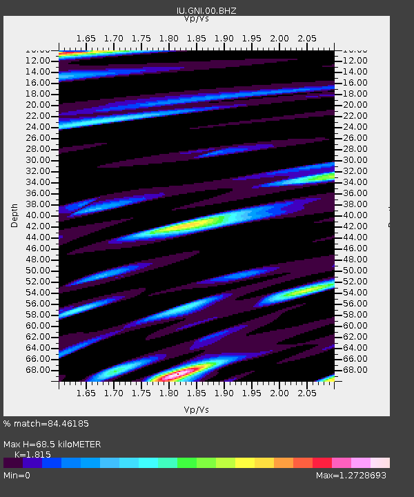
| Estimated Moho Depth: |
68.5 km |
| Estimated Crust Vp/Vs: |
1.82 |
| Assumed Crust Vp: |
6.291 km/s |
| Estimated Crust Vs: |
3.466 km/s |
| Estimated Crust Poisson's Ratio: |
0.28 |
|
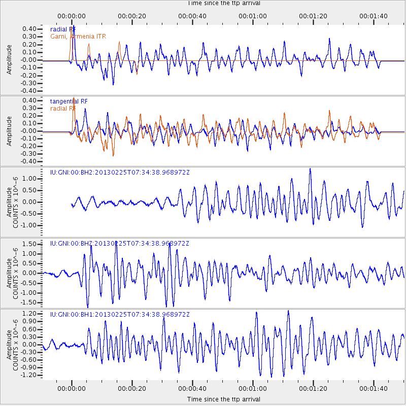
| Radial Match: |
84.46185 % |
| Radial Bump: |
400 |
| Transverse Match: |
81.7394 % |
| Transverse Bump: |
399 |
| SOD ConfigId: |
558545 |
| Insert Time: |
2013-09-18 08:15:03.446 +0000 |
| GWidth: |
2.5 |
| Max Bumps: |
400 |
| Tol: |
0.001 |
|
Signal To Noise
| Channel | StoN | STA | LTA |
| IU:GNI:00:BHZ:20130225T07:34:38.968972Z | 5.2764053 | 3.8203686E-7 | 7.240476E-8 |
| IU:GNI:00:BH1:20130225T07:34:38.968972Z | 0.68249726 | 9.2983555E-8 | 1.3624019E-7 |
| IU:GNI:00:BH2:20130225T07:34:38.968972Z | 1.3543469 | 1.5217827E-7 | 1.1236284E-7 |
| Arrivals |
| Ps | 9.2 SECOND |
| PpPs | 30 SECOND |
| PsPs/PpSs | 39 SECOND |


