You are here: Home > Network List > IU - Global Seismograph Network (GSN - IRIS/USGS) Stations List
> Station GNI Garni, Armenia > Earthquake Result Viewer
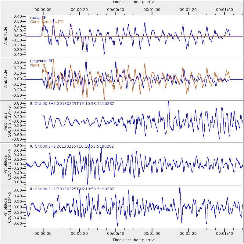
GNI Garni, Armenia - Earthquake Result Viewer
*The percent match for this event was below the threshold and hence no stack was calculated.
| Earthquake location: |
Southeast Of Ryukyu Islands |
| Earthquake latitude/longitude: |
29.0/131.5 |
| Earthquake time(UTC): |
2013/02/25 (056) 16:00:19 GMT |
| Earthquake Depth: |
46 km |
| Earthquake Magnitude: |
5.5 MB, 5.4 MW |
| Earthquake Catalog/Contributor: |
WHDF/NEIC |
|
| Network: |
IU Global Seismograph Network (GSN - IRIS/USGS) |
| Station: |
GNI Garni, Armenia |
| Lat/Lon: |
40.15 N/44.74 E |
| Elevation: |
1609 m |
|
| Distance: |
69.6 deg |
| Az: |
305.29 deg |
| Baz: |
68.864 deg |
| Ray Param: |
$rayparam |
*The percent match for this event was below the threshold and hence was not used in the summary stack. |
|
| Radial Match: |
71.46633 % |
| Radial Bump: |
400 |
| Transverse Match: |
61.256634 % |
| Transverse Bump: |
400 |
| SOD ConfigId: |
558545 |
| Insert Time: |
2013-09-18 08:18:38.771 +0000 |
| GWidth: |
2.5 |
| Max Bumps: |
400 |
| Tol: |
0.001 |
|
Signal To Noise
| Channel | StoN | STA | LTA |
| IU:GNI:00:BHZ:20130225T16:10:53.519028Z | 2.2978277 | 2.1642803E-7 | 9.41881E-8 |
| IU:GNI:00:BH1:20130225T16:10:53.519028Z | 0.7920201 | 1.1556271E-7 | 1.4590883E-7 |
| IU:GNI:00:BH2:20130225T16:10:53.519028Z | 1.0789399 | 1.4576312E-7 | 1.3509847E-7 |
| Arrivals |
| Ps | |
| PpPs | |
| PsPs/PpSs | |


