You are here: Home > Network List > IU - Global Seismograph Network (GSN - IRIS/USGS) Stations List
> Station CTAO Charters Towers, Australia > Earthquake Result Viewer
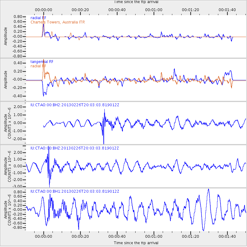
CTAO Charters Towers, Australia - Earthquake Result Viewer
*The percent match for this event was below the threshold and hence no stack was calculated.
| Earthquake location: |
Fiji Islands Region |
| Earthquake latitude/longitude: |
-21.5/-179.4 |
| Earthquake time(UTC): |
2013/02/26 (057) 19:57:55 GMT |
| Earthquake Depth: |
625 km |
| Earthquake Magnitude: |
5.7 MW, 5.7 MW |
| Earthquake Catalog/Contributor: |
NEIC PDE/NEIC PDE-W |
|
| Network: |
IU Global Seismograph Network (GSN - IRIS/USGS) |
| Station: |
CTAO Charters Towers, Australia |
| Lat/Lon: |
20.09 S/146.25 E |
| Elevation: |
357 m |
|
| Distance: |
32.1 deg |
| Az: |
266.204 deg |
| Baz: |
98.659 deg |
| Ray Param: |
$rayparam |
*The percent match for this event was below the threshold and hence was not used in the summary stack. |
|
| Radial Match: |
69.96363 % |
| Radial Bump: |
400 |
| Transverse Match: |
69.918884 % |
| Transverse Bump: |
400 |
| SOD ConfigId: |
558545 |
| Insert Time: |
2013-09-18 08:24:51.631 +0000 |
| GWidth: |
2.5 |
| Max Bumps: |
400 |
| Tol: |
0.001 |
|
Signal To Noise
| Channel | StoN | STA | LTA |
| IU:CTAO:00:BHZ:20130226T20:03:03.819012Z | 3.256165 | 1.1498494E-6 | 3.5312993E-7 |
| IU:CTAO:00:BH1:20130226T20:03:03.819012Z | 2.0816567 | 4.5522822E-7 | 2.1868554E-7 |
| IU:CTAO:00:BH2:20130226T20:03:03.819012Z | 2.6738498 | 6.8254565E-7 | 2.55267E-7 |
| Arrivals |
| Ps | |
| PpPs | |
| PsPs/PpSs | |


