You are here: Home > Network List > IU - Global Seismograph Network (GSN - IRIS/USGS) Stations List
> Station RSSD Black Hills, South Dakota, USA > Earthquake Result Viewer
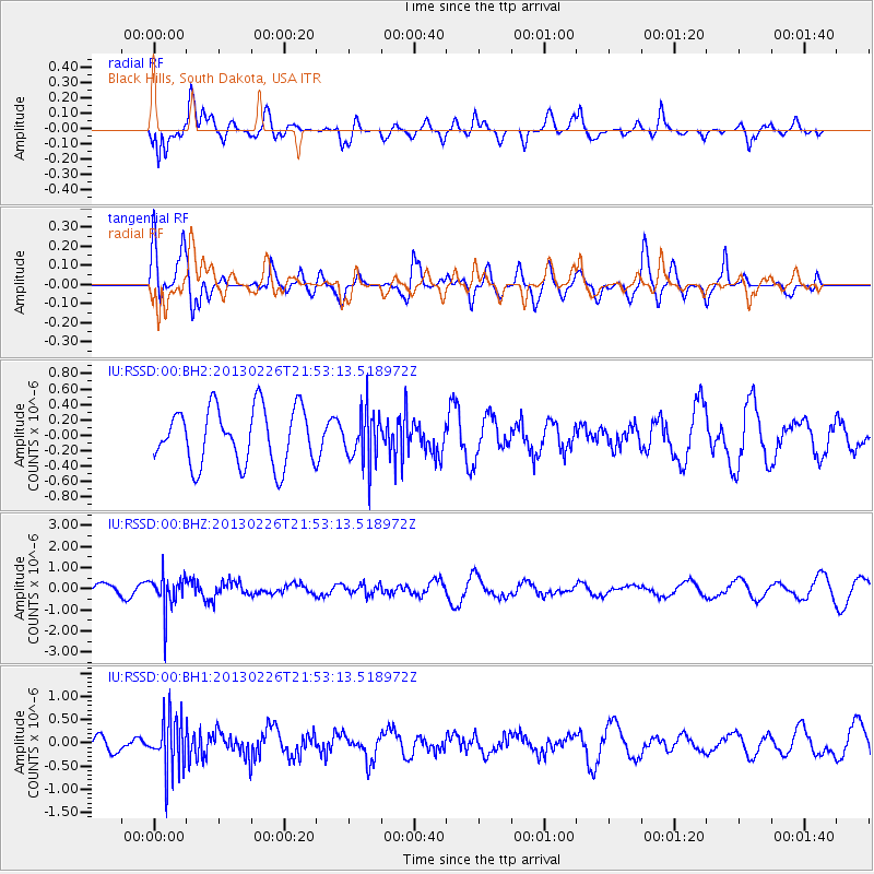
RSSD Black Hills, South Dakota, USA - Earthquake Result Viewer
*The percent match for this event was below the threshold and hence no stack was calculated.
| Earthquake location: |
Kamchatka Peninsula, Russia |
| Earthquake latitude/longitude: |
53.1/157.9 |
| Earthquake time(UTC): |
2013/02/26 (057) 21:43:48 GMT |
| Earthquake Depth: |
134 km |
| Earthquake Magnitude: |
5.6 MB |
| Earthquake Catalog/Contributor: |
NEIC PDE/NEIC PDE-W |
|
| Network: |
IU Global Seismograph Network (GSN - IRIS/USGS) |
| Station: |
RSSD Black Hills, South Dakota, USA |
| Lat/Lon: |
44.12 N/104.04 W |
| Elevation: |
2090 m |
|
| Distance: |
60.5 deg |
| Az: |
55.034 deg |
| Baz: |
316.655 deg |
| Ray Param: |
$rayparam |
*The percent match for this event was below the threshold and hence was not used in the summary stack. |
|
| Radial Match: |
65.75466 % |
| Radial Bump: |
400 |
| Transverse Match: |
68.72305 % |
| Transverse Bump: |
400 |
| SOD ConfigId: |
558545 |
| Insert Time: |
2013-09-18 08:27:48.478 +0000 |
| GWidth: |
2.5 |
| Max Bumps: |
400 |
| Tol: |
0.001 |
|
Signal To Noise
| Channel | StoN | STA | LTA |
| IU:RSSD:00:BHZ:20130226T21:53:13.518972Z | 3.066317 | 8.195626E-7 | 2.6727915E-7 |
| IU:RSSD:00:BH1:20130226T21:53:13.518972Z | 2.7933567 | 5.7521225E-7 | 2.0592152E-7 |
| IU:RSSD:00:BH2:20130226T21:53:13.518972Z | 0.90532523 | 3.3153387E-7 | 3.6620415E-7 |
| Arrivals |
| Ps | |
| PpPs | |
| PsPs/PpSs | |


