You are here: Home > Network List > II - Global Seismograph Network (GSN - IRIS/IDA) Stations List
> Station WRAB Tennant Creek, NT, Australia > Earthquake Result Viewer
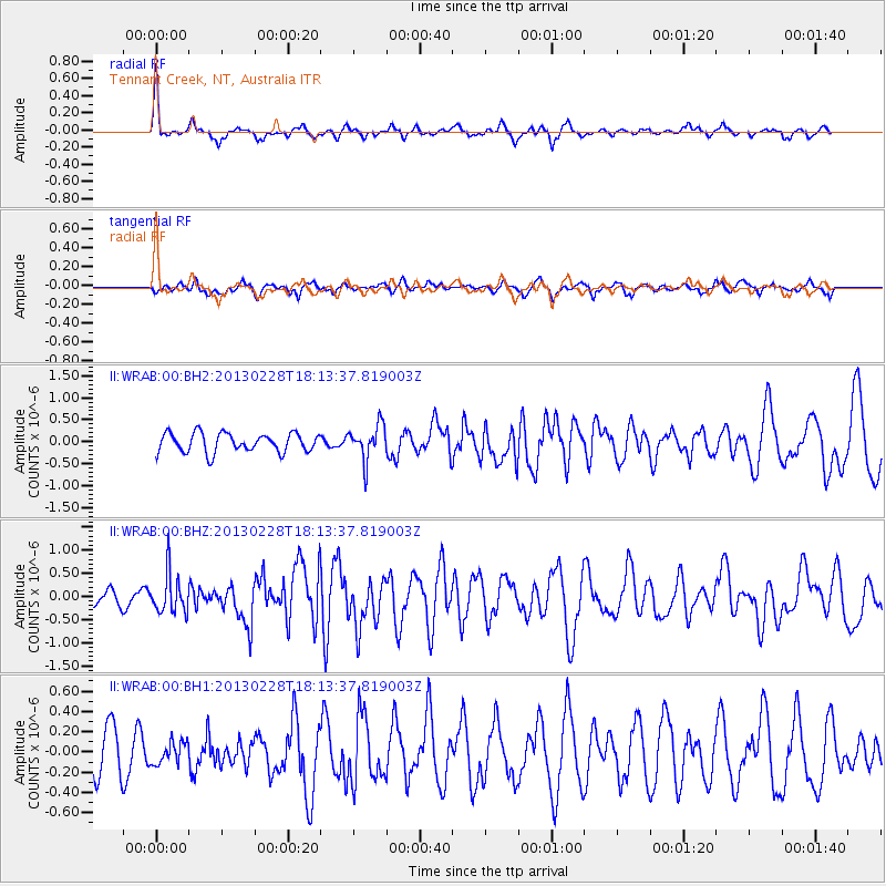
WRAB Tennant Creek, NT, Australia - Earthquake Result Viewer
*The percent match for this event was below the threshold and hence no stack was calculated.
| Earthquake location: |
Santa Cruz Islands |
| Earthquake latitude/longitude: |
-10.9/165.9 |
| Earthquake time(UTC): |
2013/02/28 (059) 18:07:48 GMT |
| Earthquake Depth: |
39 km |
| Earthquake Magnitude: |
5.5 MB, 5.4 MS, 5.8 MW, 5.8 MW |
| Earthquake Catalog/Contributor: |
WHDF/NEIC |
|
| Network: |
II Global Seismograph Network (GSN - IRIS/IDA) |
| Station: |
WRAB Tennant Creek, NT, Australia |
| Lat/Lon: |
19.93 S/134.36 E |
| Elevation: |
366 m |
|
| Distance: |
31.7 deg |
| Az: |
249.677 deg |
| Baz: |
78.241 deg |
| Ray Param: |
$rayparam |
*The percent match for this event was below the threshold and hence was not used in the summary stack. |
|
| Radial Match: |
69.05066 % |
| Radial Bump: |
321 |
| Transverse Match: |
62.281578 % |
| Transverse Bump: |
400 |
| SOD ConfigId: |
558545 |
| Insert Time: |
2013-09-18 08:38:52.048 +0000 |
| GWidth: |
2.5 |
| Max Bumps: |
400 |
| Tol: |
0.001 |
|
Signal To Noise
| Channel | StoN | STA | LTA |
| II:WRAB:00:BHZ:20130228T18:13:37.819003Z | 1.2046242 | 4.2194998E-7 | 3.502752E-7 |
| II:WRAB:00:BH1:20130228T18:13:37.819003Z | 0.46314391 | 1.0845832E-7 | 2.3417844E-7 |
| II:WRAB:00:BH2:20130228T18:13:37.819003Z | 1.8531346 | 3.97091E-7 | 2.142807E-7 |
| Arrivals |
| Ps | |
| PpPs | |
| PsPs/PpSs | |


