You are here: Home > Network List > US - United States National Seismic Network Stations List
> Station AMTX Amarillo, Texas, USA > Earthquake Result Viewer
AMTX Amarillo, Texas, USA - Earthquake Result Viewer
*The percent match for this event was below the threshold and hence no stack was calculated.
| Earthquake location: |
Kuril Islands |
| Earthquake latitude/longitude: |
50.9/157.5 |
| Earthquake time(UTC): |
2013/03/01 (060) 12:53:51 GMT |
| Earthquake Depth: |
33 km |
| Earthquake Magnitude: |
5.7 MB, 5.8 MS, 6.4 MW, 6.4 MW |
| Earthquake Catalog/Contributor: |
WHDF/NEIC |
|
| Network: |
US United States National Seismic Network |
| Station: |
AMTX Amarillo, Texas, USA |
| Lat/Lon: |
34.53 N/101.41 W |
| Elevation: |
1010 m |
|
| Distance: |
70.4 deg |
| Az: |
59.31 deg |
| Baz: |
318.728 deg |
| Ray Param: |
$rayparam |
*The percent match for this event was below the threshold and hence was not used in the summary stack. |
|
| Radial Match: |
67.81601 % |
| Radial Bump: |
400 |
| Transverse Match: |
54.723423 % |
| Transverse Bump: |
400 |
| SOD ConfigId: |
558545 |
| Insert Time: |
2013-09-18 08:46:15.909 +0000 |
| GWidth: |
2.5 |
| Max Bumps: |
400 |
| Tol: |
0.001 |
|
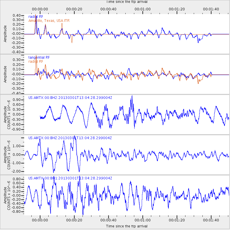
Signal To Noise
| Channel | StoN | STA | LTA |
| US:AMTX:00:BHZ:20130301T13:04:28.299004Z | 3.272597 | 9.14521E-7 | 2.794481E-7 |
| US:AMTX:00:BH1:20130301T13:04:28.299004Z | 2.2442684 | 4.4040328E-7 | 1.9623467E-7 |
| US:AMTX:00:BH2:20130301T13:04:28.299004Z | 1.1208484 | 3.8962855E-7 | 3.476193E-7 |
| Arrivals |
| Ps | |
| PpPs | |
| PsPs/PpSs | |


