You are here: Home > Network List > US - United States National Seismic Network Stations List
> Station HDIL Hopedale, Illinois, USA > Earthquake Result Viewer
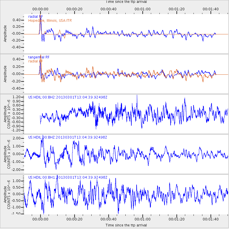
HDIL Hopedale, Illinois, USA - Earthquake Result Viewer
*The percent match for this event was below the threshold and hence no stack was calculated.
| Earthquake location: |
Kuril Islands |
| Earthquake latitude/longitude: |
50.9/157.5 |
| Earthquake time(UTC): |
2013/03/01 (060) 12:53:51 GMT |
| Earthquake Depth: |
33 km |
| Earthquake Magnitude: |
5.7 MB, 5.8 MS, 6.4 MW, 6.4 MW |
| Earthquake Catalog/Contributor: |
WHDF/NEIC |
|
| Network: |
US United States National Seismic Network |
| Station: |
HDIL Hopedale, Illinois, USA |
| Lat/Lon: |
40.56 N/89.29 W |
| Elevation: |
219 m |
|
| Distance: |
71.9 deg |
| Az: |
47.434 deg |
| Baz: |
322.254 deg |
| Ray Param: |
$rayparam |
*The percent match for this event was below the threshold and hence was not used in the summary stack. |
|
| Radial Match: |
65.412964 % |
| Radial Bump: |
400 |
| Transverse Match: |
52.72367 % |
| Transverse Bump: |
400 |
| SOD ConfigId: |
558545 |
| Insert Time: |
2013-09-18 08:47:15.055 +0000 |
| GWidth: |
2.5 |
| Max Bumps: |
400 |
| Tol: |
0.001 |
|
Signal To Noise
| Channel | StoN | STA | LTA |
| US:HDIL:00:BHZ:20130301T13:04:39.92498Z | 4.09468 | 1.0665074E-6 | 2.6046172E-7 |
| US:HDIL:00:BH1:20130301T13:04:39.92498Z | 1.3934641 | 6.344044E-7 | 4.5527145E-7 |
| US:HDIL:00:BH2:20130301T13:04:39.92498Z | 1.8419504 | 5.1503395E-7 | 2.7961335E-7 |
| Arrivals |
| Ps | |
| PpPs | |
| PsPs/PpSs | |


