You are here: Home > Network List > IU - Global Seismograph Network (GSN - IRIS/USGS) Stations List
> Station WVT Waverly, Tennessee, USA > Earthquake Result Viewer
WVT Waverly, Tennessee, USA - Earthquake Result Viewer

| Earthquake location: |
Kuril Islands |
| Earthquake latitude/longitude: |
51.0/157.4 |
| Earthquake time(UTC): |
2013/03/01 (060) 13:20:49 GMT |
| Earthquake Depth: |
29 km |
| Earthquake Magnitude: |
6.3 MB, 6.3 MS, 6.5 MW, 6.4 MW |
| Earthquake Catalog/Contributor: |
WHDF/NEIC |
|
| Network: |
IU Global Seismograph Network (GSN - IRIS/USGS) |
| Station: |
WVT Waverly, Tennessee, USA |
| Lat/Lon: |
36.13 N/87.83 W |
| Elevation: |
170 m |
|
| Distance: |
76.1 deg |
| Az: |
49.228 deg |
| Baz: |
323.728 deg |
| Ray Param: |
0.05118483 |
| Estimated Moho Depth: |
16.75 km |
| Estimated Crust Vp/Vs: |
2.10 |
| Assumed Crust Vp: |
6.444 km/s |
| Estimated Crust Vs: |
3.072 km/s |
| Estimated Crust Poisson's Ratio: |
0.35 |
|
| Radial Match: |
91.791374 % |
| Radial Bump: |
340 |
| Transverse Match: |
46.374233 % |
| Transverse Bump: |
335 |
| SOD ConfigId: |
558545 |
| Insert Time: |
2013-09-18 08:51:27.583 +0000 |
| GWidth: |
2.5 |
| Max Bumps: |
400 |
| Tol: |
0.001 |
|
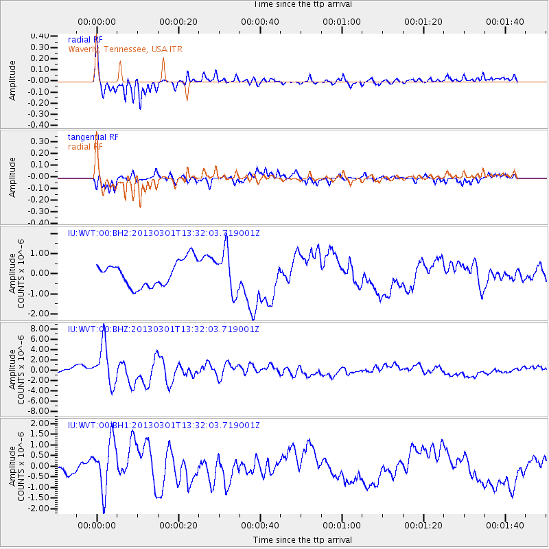
Signal To Noise
| Channel | StoN | STA | LTA |
| IU:WVT:00:BHZ:20130301T13:32:03.719001Z | 9.064945 | 4.0659666E-6 | 4.4853735E-7 |
| IU:WVT:00:BH1:20130301T13:32:03.719001Z | 2.8636062 | 1.1911033E-6 | 4.159452E-7 |
| IU:WVT:00:BH2:20130301T13:32:03.719001Z | 1.6989933 | 1.0588924E-6 | 6.2324693E-7 |
| Arrivals |
| Ps | 2.9 SECOND |
| PpPs | 7.8 SECOND |
| PsPs/PpSs | 11 SECOND |


