You are here: Home > Network List > US - United States National Seismic Network Stations List
> Station DGMT Dagmar, Montana, USA > Earthquake Result Viewer
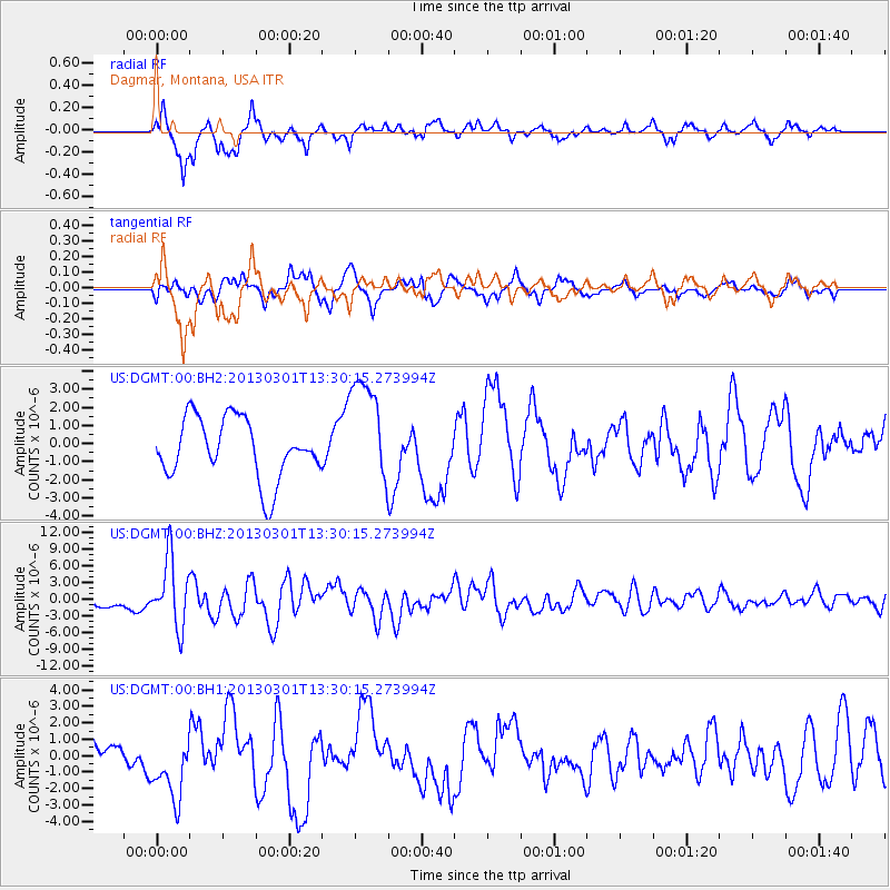
DGMT Dagmar, Montana, USA - Earthquake Result Viewer
*The percent match for this event was below the threshold and hence no stack was calculated.
| Earthquake location: |
Kuril Islands |
| Earthquake latitude/longitude: |
51.0/157.4 |
| Earthquake time(UTC): |
2013/03/01 (060) 13:20:49 GMT |
| Earthquake Depth: |
29 km |
| Earthquake Magnitude: |
6.3 MB, 6.3 MS, 6.5 MW, 6.4 MW |
| Earthquake Catalog/Contributor: |
WHDF/NEIC |
|
| Network: |
US United States National Seismic Network |
| Station: |
DGMT Dagmar, Montana, USA |
| Lat/Lon: |
48.47 N/104.20 W |
| Elevation: |
0.0 m |
|
| Distance: |
58.9 deg |
| Az: |
50.262 deg |
| Baz: |
313.049 deg |
| Ray Param: |
$rayparam |
*The percent match for this event was below the threshold and hence was not used in the summary stack. |
|
| Radial Match: |
83.52135 % |
| Radial Bump: |
400 |
| Transverse Match: |
60.30914 % |
| Transverse Bump: |
400 |
| SOD ConfigId: |
558545 |
| Insert Time: |
2013-09-18 08:52:33.900 +0000 |
| GWidth: |
2.5 |
| Max Bumps: |
400 |
| Tol: |
0.001 |
|
Signal To Noise
| Channel | StoN | STA | LTA |
| US:DGMT:00:BHZ:20130301T13:30:15.273994Z | 4.6722198 | 6.1037613E-6 | 1.3063943E-6 |
| US:DGMT:00:BH1:20130301T13:30:15.273994Z | 2.131681 | 1.9948009E-6 | 9.3578774E-7 |
| US:DGMT:00:BH2:20130301T13:30:15.273994Z | 1.8252735 | 3.0311132E-6 | 1.660635E-6 |
| Arrivals |
| Ps | |
| PpPs | |
| PsPs/PpSs | |


