You are here: Home > Network List > US - United States National Seismic Network Stations List
> Station SCIA State Center, Iowa, USA > Earthquake Result Viewer
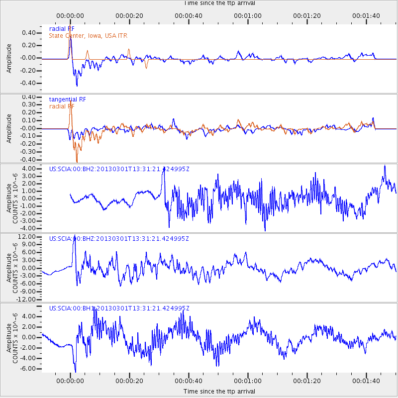
SCIA State Center, Iowa, USA - Earthquake Result Viewer

| Earthquake location: |
Kuril Islands |
| Earthquake latitude/longitude: |
51.0/157.4 |
| Earthquake time(UTC): |
2013/03/01 (060) 13:20:49 GMT |
| Earthquake Depth: |
29 km |
| Earthquake Magnitude: |
6.3 MB, 6.3 MS, 6.5 MW, 6.4 MW |
| Earthquake Catalog/Contributor: |
WHDF/NEIC |
|
| Network: |
US United States National Seismic Network |
| Station: |
SCIA State Center, Iowa, USA |
| Lat/Lon: |
41.91 N/93.22 W |
| Elevation: |
312 m |
|
| Distance: |
69.0 deg |
| Az: |
48.974 deg |
| Baz: |
320.269 deg |
| Ray Param: |
0.055913318 |
| Estimated Moho Depth: |
46.25 km |
| Estimated Crust Vp/Vs: |
1.75 |
| Assumed Crust Vp: |
6.498 km/s |
| Estimated Crust Vs: |
3.724 km/s |
| Estimated Crust Poisson's Ratio: |
0.26 |
|
| Radial Match: |
89.71178 % |
| Radial Bump: |
310 |
| Transverse Match: |
51.247932 % |
| Transverse Bump: |
398 |
| SOD ConfigId: |
558545 |
| Insert Time: |
2013-09-18 08:54:16.759 +0000 |
| GWidth: |
2.5 |
| Max Bumps: |
400 |
| Tol: |
0.001 |
|
Signal To Noise
| Channel | StoN | STA | LTA |
| US:SCIA:00:BHZ:20130301T13:31:21.424995Z | 5.2949286 | 5.018012E-6 | 9.4770155E-7 |
| US:SCIA:00:BH1:20130301T13:31:21.424995Z | 3.6262062 | 2.5551353E-6 | 7.0463045E-7 |
| US:SCIA:00:BH2:20130301T13:31:21.424995Z | 3.2096531 | 1.8882644E-6 | 5.883079E-7 |
| Arrivals |
| Ps | 5.5 SECOND |
| PpPs | 19 SECOND |
| PsPs/PpSs | 24 SECOND |


