You are here: Home > Network List > CN - Canadian National Seismograph Network Stations List
> Station FRB IQALUIT, N.W.T. > Earthquake Result Viewer
FRB IQALUIT, N.W.T. - Earthquake Result Viewer

| Earthquake location: |
Azores Islands, Portugal |
| Earthquake latitude/longitude: |
38.7/-28.6 |
| Earthquake time(UTC): |
1998/07/09 (190) 05:19:07 GMT |
| Earthquake Depth: |
10 km |
| Earthquake Magnitude: |
5.7 MB, 6.0 MS, 6.6 UNKNOWN, 6.2 MW |
| Earthquake Catalog/Contributor: |
WHDF/NEIC |
|
| Network: |
CN Canadian National Seismograph Network |
| Station: |
FRB IQALUIT, N.W.T. |
| Lat/Lon: |
63.75 N/68.55 W |
| Elevation: |
18 m |
|
| Distance: |
34.5 deg |
| Az: |
329.739 deg |
| Baz: |
117.47 deg |
| Ray Param: |
0.0777122 |
| Estimated Moho Depth: |
41.0 km |
| Estimated Crust Vp/Vs: |
1.77 |
| Assumed Crust Vp: |
6.419 km/s |
| Estimated Crust Vs: |
3.627 km/s |
| Estimated Crust Poisson's Ratio: |
0.27 |
|
| Radial Match: |
95.1453 % |
| Radial Bump: |
249 |
| Transverse Match: |
66.671646 % |
| Transverse Bump: |
400 |
| SOD ConfigId: |
4480 |
| Insert Time: |
2010-02-27 05:41:17.488 +0000 |
| GWidth: |
2.5 |
| Max Bumps: |
400 |
| Tol: |
0.001 |
|
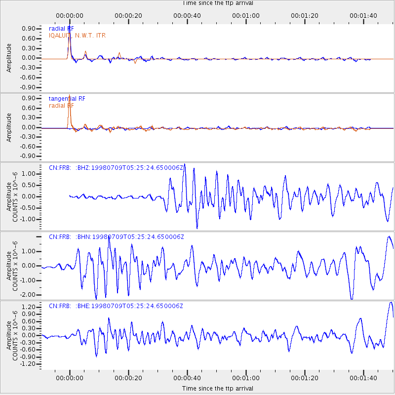
Signal To Noise
| Channel | StoN | STA | LTA |
| CN:FRB: :BHN:19980709T05:25:24.650006Z | 10.174492 | 6.754477E-7 | 6.6386384E-8 |
| CN:FRB: :BHE:19980709T05:25:24.650006Z | 4.756982 | 1.6164424E-7 | 3.398042E-8 |
| CN:FRB: :BHZ:19980709T05:25:24.650006Z | 7.908766 | 3.5797433E-7 | 4.5262983E-8 |
| Arrivals |
| Ps | 5.3 SECOND |
| PpPs | 16 SECOND |
| PsPs/PpSs | 22 SECOND |


