You are here: Home > Network List > II - Global Seismograph Network (GSN - IRIS/IDA) Stations List
> Station WRAB Tennant Creek, NT, Australia > Earthquake Result Viewer
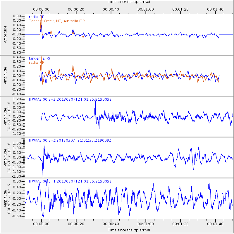
WRAB Tennant Creek, NT, Australia - Earthquake Result Viewer
*The percent match for this event was below the threshold and hence no stack was calculated.
| Earthquake location: |
Vanuatu Islands |
| Earthquake latitude/longitude: |
-19.0/169.4 |
| Earthquake time(UTC): |
2013/03/07 (066) 20:55:52 GMT |
| Earthquake Depth: |
236 km |
| Earthquake Magnitude: |
5.5 MB, 5.5 MW, 5.5 MW |
| Earthquake Catalog/Contributor: |
WHDF/NEIC |
|
| Network: |
II Global Seismograph Network (GSN - IRIS/IDA) |
| Station: |
WRAB Tennant Creek, NT, Australia |
| Lat/Lon: |
19.93 S/134.36 E |
| Elevation: |
366 m |
|
| Distance: |
33.0 deg |
| Az: |
262.429 deg |
| Baz: |
94.352 deg |
| Ray Param: |
$rayparam |
*The percent match for this event was below the threshold and hence was not used in the summary stack. |
|
| Radial Match: |
50.938286 % |
| Radial Bump: |
400 |
| Transverse Match: |
38.456516 % |
| Transverse Bump: |
400 |
| SOD ConfigId: |
558545 |
| Insert Time: |
2013-09-18 09:05:41.480 +0000 |
| GWidth: |
2.5 |
| Max Bumps: |
400 |
| Tol: |
0.001 |
|
Signal To Noise
| Channel | StoN | STA | LTA |
| II:WRAB:00:BHZ:20130307T21:01:35.219009Z | 4.0722733 | 6.2285113E-7 | 1.5294926E-7 |
| II:WRAB:00:BH1:20130307T21:01:35.219009Z | 2.7962818 | 4.1976156E-7 | 1.5011419E-7 |
| II:WRAB:00:BH2:20130307T21:01:35.219009Z | 2.63774 | 3.867469E-7 | 1.4662055E-7 |
| Arrivals |
| Ps | |
| PpPs | |
| PsPs/PpSs | |


