You are here: Home > Network List > IU - Global Seismograph Network (GSN - IRIS/USGS) Stations List
> Station CCM Cathedral Cave, Missouri, USA > Earthquake Result Viewer
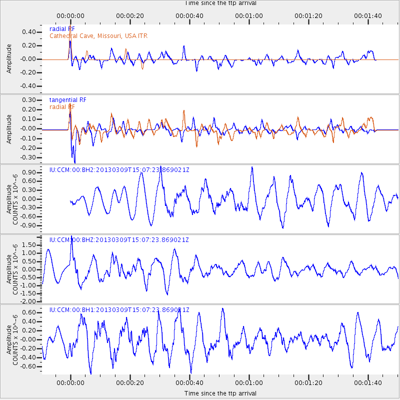
CCM Cathedral Cave, Missouri, USA - Earthquake Result Viewer
*The percent match for this event was below the threshold and hence no stack was calculated.
| Earthquake location: |
Kuril Islands |
| Earthquake latitude/longitude: |
50.9/157.2 |
| Earthquake time(UTC): |
2013/03/09 (068) 14:56:28 GMT |
| Earthquake Depth: |
39 km |
| Earthquake Magnitude: |
5.7 MB, 5.3 MS, 5.8 MW, 5.9 MW |
| Earthquake Catalog/Contributor: |
WHDF/NEIC |
|
| Network: |
IU Global Seismograph Network (GSN - IRIS/USGS) |
| Station: |
CCM Cathedral Cave, Missouri, USA |
| Lat/Lon: |
38.06 N/91.24 W |
| Elevation: |
222 m |
|
| Distance: |
73.1 deg |
| Az: |
50.142 deg |
| Baz: |
321.985 deg |
| Ray Param: |
$rayparam |
*The percent match for this event was below the threshold and hence was not used in the summary stack. |
|
| Radial Match: |
58.575333 % |
| Radial Bump: |
400 |
| Transverse Match: |
72.73834 % |
| Transverse Bump: |
400 |
| SOD ConfigId: |
558545 |
| Insert Time: |
2013-09-18 09:08:11.597 +0000 |
| GWidth: |
2.5 |
| Max Bumps: |
400 |
| Tol: |
0.001 |
|
Signal To Noise
| Channel | StoN | STA | LTA |
| IU:CCM:00:BHZ:20130309T15:07:23.869021Z | 1.6296893 | 8.9314676E-7 | 5.4804724E-7 |
| IU:CCM:00:BH1:20130309T15:07:23.869021Z | 1.6077509 | 3.3607364E-7 | 2.090334E-7 |
| IU:CCM:00:BH2:20130309T15:07:23.869021Z | 1.468818 | 5.408716E-7 | 3.68236E-7 |
| Arrivals |
| Ps | |
| PpPs | |
| PsPs/PpSs | |


