You are here: Home > Network List > IU - Global Seismograph Network (GSN - IRIS/USGS) Stations List
> Station RSSD Black Hills, South Dakota, USA > Earthquake Result Viewer
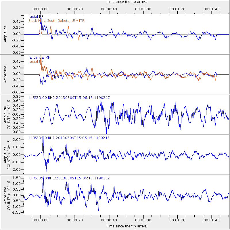
RSSD Black Hills, South Dakota, USA - Earthquake Result Viewer
*The percent match for this event was below the threshold and hence no stack was calculated.
| Earthquake location: |
Kuril Islands |
| Earthquake latitude/longitude: |
50.9/157.2 |
| Earthquake time(UTC): |
2013/03/09 (068) 14:56:28 GMT |
| Earthquake Depth: |
39 km |
| Earthquake Magnitude: |
5.7 MB, 5.3 MS, 5.8 MW, 5.9 MW |
| Earthquake Catalog/Contributor: |
WHDF/NEIC |
|
| Network: |
IU Global Seismograph Network (GSN - IRIS/USGS) |
| Station: |
RSSD Black Hills, South Dakota, USA |
| Lat/Lon: |
44.12 N/104.04 W |
| Elevation: |
2090 m |
|
| Distance: |
62.1 deg |
| Az: |
53.635 deg |
| Baz: |
314.917 deg |
| Ray Param: |
$rayparam |
*The percent match for this event was below the threshold and hence was not used in the summary stack. |
|
| Radial Match: |
56.895622 % |
| Radial Bump: |
400 |
| Transverse Match: |
66.35004 % |
| Transverse Bump: |
400 |
| SOD ConfigId: |
558545 |
| Insert Time: |
2013-09-18 09:08:56.552 +0000 |
| GWidth: |
2.5 |
| Max Bumps: |
400 |
| Tol: |
0.001 |
|
Signal To Noise
| Channel | StoN | STA | LTA |
| IU:RSSD:00:BHZ:20130309T15:06:15.119021Z | 4.6090612 | 9.919285E-7 | 2.1521268E-7 |
| IU:RSSD:00:BH1:20130309T15:06:15.119021Z | 2.5629692 | 5.9237084E-7 | 2.3112679E-7 |
| IU:RSSD:00:BH2:20130309T15:06:15.119021Z | 1.5024985 | 3.2142597E-7 | 2.1392765E-7 |
| Arrivals |
| Ps | |
| PpPs | |
| PsPs/PpSs | |


