You are here: Home > Network List > US - United States National Seismic Network Stations List
> Station BOZ Bozeman, Montana, USA > Earthquake Result Viewer
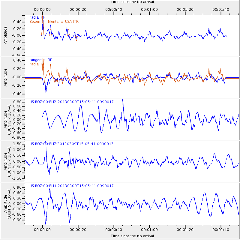
BOZ Bozeman, Montana, USA - Earthquake Result Viewer
*The percent match for this event was below the threshold and hence no stack was calculated.
| Earthquake location: |
Kuril Islands |
| Earthquake latitude/longitude: |
50.9/157.2 |
| Earthquake time(UTC): |
2013/03/09 (068) 14:56:28 GMT |
| Earthquake Depth: |
39 km |
| Earthquake Magnitude: |
5.7 MB, 5.3 MS, 5.8 MW, 5.9 MW |
| Earthquake Catalog/Contributor: |
WHDF/NEIC |
|
| Network: |
US United States National Seismic Network |
| Station: |
BOZ Bozeman, Montana, USA |
| Lat/Lon: |
45.65 N/111.63 W |
| Elevation: |
1589 m |
|
| Distance: |
57.1 deg |
| Az: |
56.609 deg |
| Baz: |
311.077 deg |
| Ray Param: |
$rayparam |
*The percent match for this event was below the threshold and hence was not used in the summary stack. |
|
| Radial Match: |
55.05033 % |
| Radial Bump: |
373 |
| Transverse Match: |
63.49728 % |
| Transverse Bump: |
400 |
| SOD ConfigId: |
558545 |
| Insert Time: |
2013-09-18 09:10:11.262 +0000 |
| GWidth: |
2.5 |
| Max Bumps: |
400 |
| Tol: |
0.001 |
|
Signal To Noise
| Channel | StoN | STA | LTA |
| US:BOZ:00:BHZ:20130309T15:05:41.099001Z | 4.067654 | 6.847268E-7 | 1.6833457E-7 |
| US:BOZ:00:BH1:20130309T15:05:41.099001Z | 2.0877292 | 5.322703E-7 | 2.549518E-7 |
| US:BOZ:00:BH2:20130309T15:05:41.099001Z | 1.0413913 | 3.197218E-7 | 3.0701412E-7 |
| Arrivals |
| Ps | |
| PpPs | |
| PsPs/PpSs | |


