You are here: Home > Network List > US - United States National Seismic Network Stations List
> Station CBKS Cedar Bluff, Kansas, USA > Earthquake Result Viewer
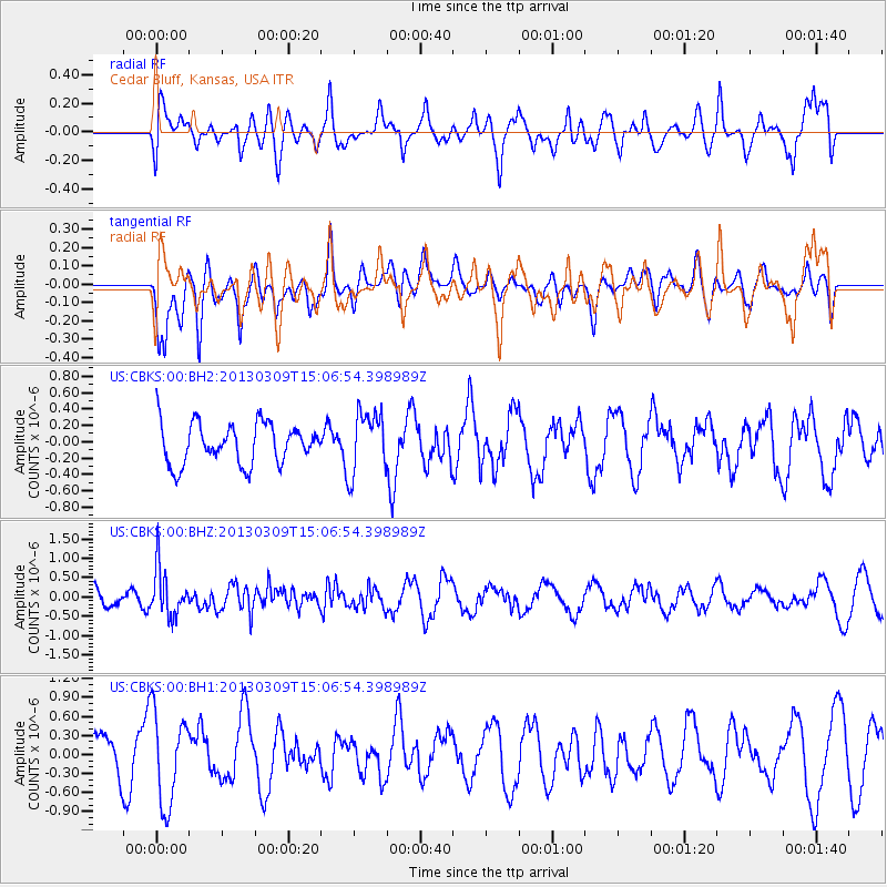
CBKS Cedar Bluff, Kansas, USA - Earthquake Result Viewer
*The percent match for this event was below the threshold and hence no stack was calculated.
| Earthquake location: |
Kuril Islands |
| Earthquake latitude/longitude: |
50.9/157.2 |
| Earthquake time(UTC): |
2013/03/09 (068) 14:56:28 GMT |
| Earthquake Depth: |
39 km |
| Earthquake Magnitude: |
5.7 MB, 5.3 MS, 5.8 MW, 5.9 MW |
| Earthquake Catalog/Contributor: |
WHDF/NEIC |
|
| Network: |
US United States National Seismic Network |
| Station: |
CBKS Cedar Bluff, Kansas, USA |
| Lat/Lon: |
38.81 N/99.74 W |
| Elevation: |
677 m |
|
| Distance: |
68.2 deg |
| Az: |
55.056 deg |
| Baz: |
318.354 deg |
| Ray Param: |
$rayparam |
*The percent match for this event was below the threshold and hence was not used in the summary stack. |
|
| Radial Match: |
79.3102 % |
| Radial Bump: |
400 |
| Transverse Match: |
67.80589 % |
| Transverse Bump: |
400 |
| SOD ConfigId: |
558545 |
| Insert Time: |
2013-09-18 09:10:17.197 +0000 |
| GWidth: |
2.5 |
| Max Bumps: |
400 |
| Tol: |
0.001 |
|
Signal To Noise
| Channel | StoN | STA | LTA |
| US:CBKS:00:BHZ:20130309T15:06:54.398989Z | 2.2574377 | 6.17122E-7 | 2.7337276E-7 |
| US:CBKS:00:BH1:20130309T15:06:54.398989Z | 2.2793424 | 7.2236077E-7 | 3.169163E-7 |
| US:CBKS:00:BH2:20130309T15:06:54.398989Z | 1.5436776 | 3.796971E-7 | 2.4596918E-7 |
| Arrivals |
| Ps | |
| PpPs | |
| PsPs/PpSs | |


