You are here: Home > Network List > CN - Canadian National Seismograph Network Stations List
> Station FRB IQALUIT, N.W.T. > Earthquake Result Viewer
FRB IQALUIT, N.W.T. - Earthquake Result Viewer
| Earthquake location: |
Pakistan |
| Earthquake latitude/longitude: |
30.0/68.2 |
| Earthquake time(UTC): |
1997/02/27 (058) 21:08:02 GMT |
| Earthquake Depth: |
33 km |
| Earthquake Magnitude: |
6.3 MB, 7.3 MS, 7.1 UNKNOWN, 6.6 ME |
| Earthquake Catalog/Contributor: |
WHDF/NEIC |
|
| Network: |
CN Canadian National Seismograph Network |
| Station: |
FRB IQALUIT, N.W.T. |
| Lat/Lon: |
63.75 N/68.55 W |
| Elevation: |
18 m |
|
| Distance: |
80.6 deg |
| Az: |
342.008 deg |
| Baz: |
37.06 deg |
| Ray Param: |
0.048154872 |
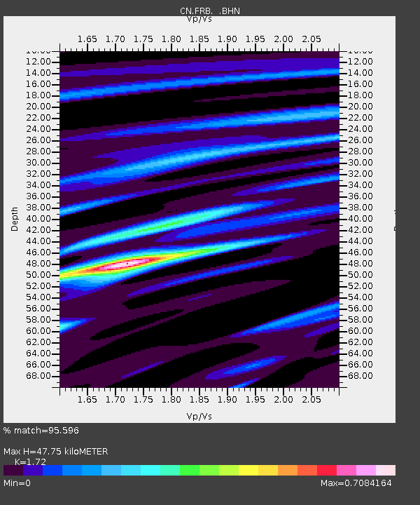
| Estimated Moho Depth: |
47.75 km |
| Estimated Crust Vp/Vs: |
1.72 |
| Assumed Crust Vp: |
6.419 km/s |
| Estimated Crust Vs: |
3.732 km/s |
| Estimated Crust Poisson's Ratio: |
0.24 |
|
| Radial Match: |
95.596 % |
| Radial Bump: |
272 |
| Transverse Match: |
82.66163 % |
| Transverse Bump: |
400 |
| SOD ConfigId: |
4480 |
| Insert Time: |
2010-02-27 05:41:50.501 +0000 |
| GWidth: |
2.5 |
| Max Bumps: |
400 |
| Tol: |
0.001 |
|

Signal To Noise
| Channel | StoN | STA | LTA |
| CN:FRB: :BHN:19970227T21:19:40.175Z | 8.835796 | 2.2444108E-6 | 2.5401343E-7 |
| CN:FRB: :BHE:19970227T21:19:40.175Z | 4.4833636 | 7.582967E-7 | 1.6913567E-7 |
| CN:FRB: :BHZ:19970227T21:19:40.175Z | 3.990797 | 5.241218E-7 | 1.3133261E-7 |
| Arrivals |
| Ps | 5.5 SECOND |
| PpPs | 20 SECOND |
| PsPs/PpSs | 25 SECOND |


