You are here: Home > Network List > US - United States National Seismic Network Stations List
> Station CBKS Cedar Bluff, Kansas, USA > Earthquake Result Viewer
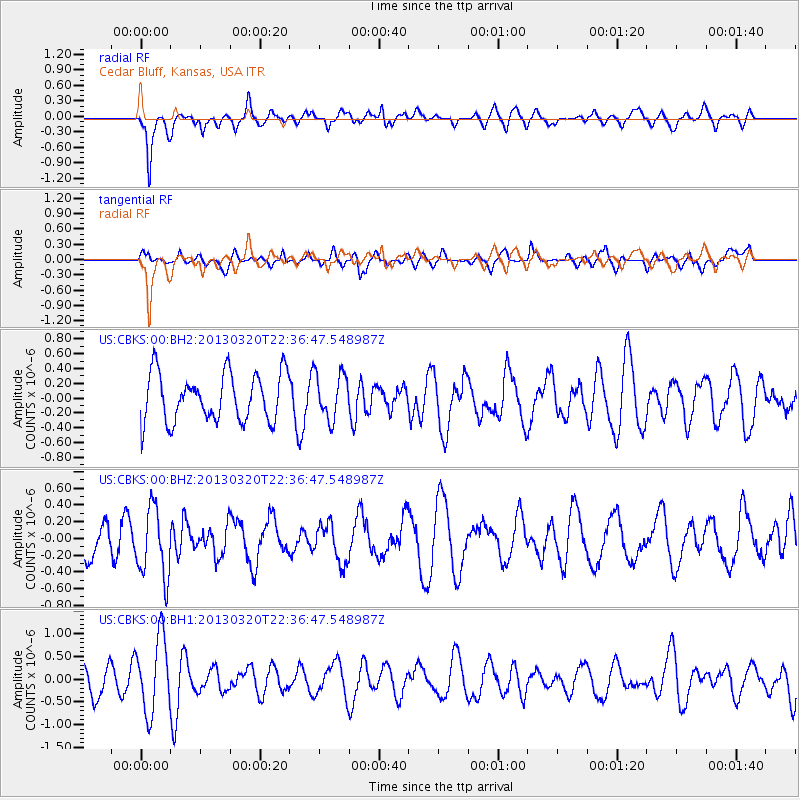
CBKS Cedar Bluff, Kansas, USA - Earthquake Result Viewer
*The percent match for this event was below the threshold and hence no stack was calculated.
| Earthquake location: |
Reykjanes Ridge |
| Earthquake latitude/longitude: |
55.5/-34.9 |
| Earthquake time(UTC): |
2013/03/20 (079) 22:29:00 GMT |
| Earthquake Depth: |
10 km |
| Earthquake Magnitude: |
5.5 MW |
| Earthquake Catalog/Contributor: |
NEIC PDE/NEIC PDE-W |
|
| Network: |
US United States National Seismic Network |
| Station: |
CBKS Cedar Bluff, Kansas, USA |
| Lat/Lon: |
38.81 N/99.74 W |
| Elevation: |
677 m |
|
| Distance: |
45.4 deg |
| Az: |
276.578 deg |
| Baz: |
46.343 deg |
| Ray Param: |
$rayparam |
*The percent match for this event was below the threshold and hence was not used in the summary stack. |
|
| Radial Match: |
79.52431 % |
| Radial Bump: |
400 |
| Transverse Match: |
47.297855 % |
| Transverse Bump: |
400 |
| SOD ConfigId: |
558545 |
| Insert Time: |
2013-09-18 09:38:48.400 +0000 |
| GWidth: |
2.5 |
| Max Bumps: |
400 |
| Tol: |
0.001 |
|
Signal To Noise
| Channel | StoN | STA | LTA |
| US:CBKS:00:BHZ:20130320T22:36:47.548987Z | 1.7779585 | 4.1552624E-7 | 2.3370977E-7 |
| US:CBKS:00:BH1:20130320T22:36:47.548987Z | 1.695801 | 8.227079E-7 | 4.851441E-7 |
| US:CBKS:00:BH2:20130320T22:36:47.548987Z | 0.94798225 | 3.0700184E-7 | 3.2384767E-7 |
| Arrivals |
| Ps | |
| PpPs | |
| PsPs/PpSs | |


